Category:Stadsmuur Zuidelijke Omwalling, Zutphen
| Object location | | View all coordinates using: OpenStreetMap |
|---|
 | |||||
| Upload media | |||||
| Instance of | |||||
|---|---|---|---|---|---|
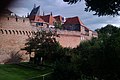
| Location | Zutphen, Gelderland, Netherlands | ||||
| Street address |
| ||||
| Heritage designation |
| ||||
 | |||||
|
This is a category about rijksmonument number 41501
|
| Address |
|
Media in category "Stadsmuur Zuidelijke Omwalling, Zutphen"
The following 8 files are in this category, out of 8 total.
-
 RM41501 Zutphen - Stadsmuur.jpg 2,592 × 1,944; 1.57 MB
-
 Zutphen - Stadsmuur 's Gravenhof.jpg 2,592 × 1,728; 1.7 MB
-
 Zutphen - Stadsmuur Waterstraat.jpg 2,592 × 1,728; 1.45 MB
-
 Zutphen langs de gracht 04.JPG 3,648 × 2,736; 4.72 MB
-
 Zutphen langs de gracht 05.JPG 3,648 × 2,736; 4.02 MB
-
 Zutphen langs de gracht 06.JPG 3,648 × 2,736; 4.63 MB
-
 Zutphen langs de gracht 07.JPG 3,648 × 2,736; 4.75 MB
-


