Category:Stadtkirche (Roth)
| Object location | | View all coordinates using: OpenStreetMap |
|---|
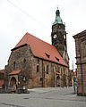
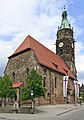
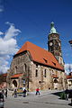
building in Roth, Bavaria, Germany  | |||||
| Upload media | |||||
| Instance of | |||||
|---|---|---|---|---|---|
| Location | Roth, Middle Franconia, Bavaria, Germany | ||||
| Street address |
| ||||
| Has part(s) |
| ||||
| Heritage designation | |||||
 | |||||
Subcategories
This category has only the following subcategory.
I
Media in category "Stadtkirche (Roth)"
The following 21 files are in this category, out of 21 total.
-
 Evangelische Stadtkirche Roth Mittelfranken aussen.JPG 2,448 × 3,264; 3.35 MB
-
 Roth bei Nürnberg - Ev. Stadtkirche - 01.jpg 3,376 × 4,220; 5.35 MB
-
 Roth evangelische Stadtkirche 20110501.jpg 2,971 × 4,260; 4.82 MB
-
 Roth Stadtkirche.jpg 1,536 × 2,048; 1.24 MB
-
 Roth wetzrillen.jpg 2,048 × 1,536; 1.32 MB
-
 Roth, die Stadtkirche.jpg 1,691 × 2,189; 948 KB
-
 Roth, Kirchplatz, Stadtpfarrkirche, 001.jpg 3,264 × 4,928; 8.9 MB
-
 Stadtkirche Roth 01.jpg 2,736 × 3,648; 2.32 MB
-
 Stadtkirche Roth 02.jpg 2,736 × 3,648; 2.45 MB
-
 Zu unserer lieben Frau - Roth 001.JPG 6,000 × 4,000; 5.53 MB
-
 Zu unserer lieben Frau - Roth 002.JPG 4,000 × 6,000; 6.77 MB
-
 Zu unserer lieben Frau - Roth 003.JPG 4,000 × 6,000; 5.58 MB
-
 Zu unserer lieben Frau - Roth 004.JPG 4,000 × 6,000; 5.44 MB
-
 Zu unserer lieben Frau - Roth 005.JPG 4,000 × 6,000; 4.44 MB
-
 Zu unserer lieben Frau - Roth 006.JPG 4,000 × 6,000; 6.61 MB
-
 Zu unserer lieben Frau - Roth 007.JPG 4,000 × 6,000; 4.72 MB
-
 Zu unserer lieben Frau - Roth 008.JPG 6,000 × 4,000; 9.84 MB
-
 Zu unserer lieben Frau - Roth 009.JPG 4,000 × 6,000; 7.34 MB
-
 Zu unserer lieben Frau - Roth 010.JPG 4,000 × 6,000; 6.07 MB
-
 Zu unserer lieben Frau - Roth 052.JPG 4,000 × 6,000; 4.09 MB
-
 Zu unserer lieben Frau - Roth 053.JPG 4,000 × 6,000; 4.76 MB


