Category:Stanegate
English: Stanegate (or Stangate) was a Roman road in northern England, just south of Hadrian's Wall. It linked Corstopitum (Corbridge) in the east to Luguvalium (Carlisle) in the west.
Roman road that ran from Carlisle to Corbridge  | |||||
| Upload media | |||||
| Instance of | |||||
|---|---|---|---|---|---|
| Part of | |||||
| Location |
| ||||
| Length |
| ||||
 | |||||
Subcategories
This category has the following 5 subcategories, out of 5 total.
Media in category "Stanegate"
The following 31 files are in this category, out of 31 total.
-
 Along the line of Stanegate - geograph.org.uk - 406233.jpg 640 × 480; 150 KB
-
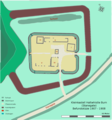
 Befundskizze Kastell Old Church-Brampton.png 1,193 × 1,200; 122 KB
-
 Befundskizze KK Haltwhistle Burn 2.Jhdt. n.Chr.png 1,114 × 1,193; 268 KB
-
 Befundskizze Luguvalium Carvetiorum (GB).png 1,324 × 1,048; 1.53 MB
-
 Blick auf Throp Farm, Gilsland, Cumbria (GB).png 1,603 × 1,216; 1.77 MB
-
 Corbridge stangate.jpg 1,024 × 766; 781 KB
-
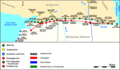 Forts on Stanegate and Hadrian's wall.png 1,987 × 1,159; 937 KB
-
 Haltwhiste Burn Kastelle.png 1,112 × 1,201; 367 KB
-
 Housesteads Fort from The Stanegate - geograph.org.uk - 704881.jpg 640 × 423; 29 KB
-
 Kastelle Nordbritannien.png 2,214 × 1,176; 941 KB
-
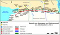 Kastelle SK und Hadrianswall 2. Jhdt..png 1,987 × 1,159; 707 KB
-
 KK Throp (GB).png 1,304 × 966; 145 KB
-
 Lageskizze Kastelle von Newbrough.png 2,147 × 1,020; 384 KB
-
 Lageskizze Kleinkastell Castle Hill (Boothby), Cumbria, GB.png 2,127 × 1,200; 420 KB
-

-
 Octavius Fulfilled His Vow (7617327004).jpg 3,449 × 3,938; 16.56 MB
-
 Roman Fort - geograph.org.uk - 451189.jpg 640 × 480; 85 KB
-
 Roman Gravestones (7617484452).jpg 4,983 × 3,255; 21.12 MB
-
 Röm. Befestigungsanlagen bei Gilsland, Stanegate und Hadrianswall.png 2,030 × 1,195; 741 KB
-

-
 Stanegate, Newbrough - geograph.org.uk - 1067318.jpg 640 × 359; 70 KB
-
 Stanegate.jpg 283 × 197; 11 KB
-
 The Stanegate above Vindolanda - geograph.org.uk - 785569.jpg 640 × 480; 57 KB
-
 The Throp, Cumbria (geograph 3706044).jpg 1,024 × 768; 127 KB
-
 West Morwood - geograph.org.uk - 785571.jpg 640 × 480; 74 KB
-
 Grindon Lough (lake) from Stanegate - geograph.org.uk - 1409183.jpg 640 × 480; 79 KB
-

-
 Roman road to Vindolanda - geograph.org.uk - 299099.jpg 480 × 640; 60 KB
-
 Roman road to Vindolanda - geograph.org.uk - 299100.jpg 640 × 493; 41 KB
-
 Stangate - geograph.org.uk - 162064.jpg 640 × 482; 88 KB
-
 The 'Stanegate' near Settlingstones - geograph.org.uk - 338814.jpg 480 × 640; 74 KB


.png)
.png)


.png)

,_Cumbria,_GB.png)

.jpg)

.jpg)


.jpg)

_from_Stanegate_-_geograph.org.uk_-_1409183.jpg)


