Category:Stanley Road bridges, Bootle
| Object location | | View all coordinates using: OpenStreetMap |
|---|
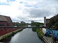
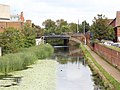
The bridge carrying Stanley Road over the Leeds and Liverpool Canal (numbered 2A) and the parallel footbridge leading to the canal walkway (tow path).
Subcategories
This category has the following 3 subcategories, out of 3 total.
C
S
Media in category "Stanley Road bridges, Bootle"
The following 9 files are in this category, out of 9 total.
-
 Stanley Road Bridge 2a looking towards Leeds July 18 2010.jpg 2,304 × 3,072; 1.14 MB
-
 Stanley Road Bridge 2a looking towards Liverpool July 18 2010.jpg 3,072 × 2,304; 1.22 MB
-
 Stanley Road bridges from Washington Parade bridge.jpg 4,434 × 3,321; 10.01 MB
-
 Stanley Road bridges underside.jpg 5,204 × 3,353; 12.03 MB
-
 Stanley Road bridges, Bootle - undersides and plates.jpg 5,025 × 3,279; 10.57 MB
-
 Stanley Road bridges, Bootle.jpg 4,473 × 3,330; 10.08 MB
-
 View north from Stanley Road bridge, Bootle.jpg 4,440 × 3,390; 9.12 MB
-
 View south from Stanley Road bridge, Bootle.jpg 4,728 × 3,051; 8.63 MB
-
 View south from Stanley Road footbridge.jpg 4,374 × 3,429; 9.89 MB


