Category:Stanwick, Northamptonshire
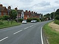
English: Stanwick (pronounced with a silent 'w') is a village and civil parish in rural Northamptonshire, England. It is located approximately 15 miles to the north-east of Northampton and is the largest village in the East Northamptonshire district.
Español: Stanwick (también conocida como Stanwick Camp) es una fortaleza de la Edad de Hierro ubicada en Richmondshire, North Yorkshire, Inglaterra .
Italiano: Stanwick è un villaggio e una parrocchia civile nel Northamptonshire (Inghilterra), ubicato a circa 15 miglia a nord-est di Northampton. Si pensa che l'area fose abitata almeno dagli inizi dell'Età del Ferro. Fu nei pressi di questo luogo cheattorno al 70 i Romani sconfissero i Briganti.
Português: Stanwick é uma povoação fortificada da Idade do Ferro (século I), situada a norte de Richmond, no condado de Yorkshire (Inglaterra). Foi um importante centro de resistência local à ocupação romana, os principais vestígios arqueológicos datam do século I d.C. De entre eles há a destacar um grande conjunto de objectos metálicos celtas, em especial arreios, para tracção de carros.
village and civil parish in Northamptonshire, England .jpg) | |||||
| Upload media | |||||
| Instance of | |||||
|---|---|---|---|---|---|
| Location | North Northamptonshire, Northamptonshire, East Midlands, England | ||||
| Population |
| ||||
| Different from | |||||
| official website | |||||
 | |||||
Subcategories
This category has the following 3 subcategories, out of 3 total.
S
- Stanwick Lakes (22 F)
- Stanwick War Memorial (2 F)
Media in category "Stanwick, Northamptonshire"
The following 31 files are in this category, out of 31 total.
-
 Bridleway by Pasture Cottages - geograph.org.uk - 1552295.jpg 640 × 480; 63 KB
-
 Bridleway to Pasture Cottages - geograph.org.uk - 1189694.jpg 640 × 480; 142 KB
-
 Chelveston Road into Raunds - geograph.org.uk - 2995431.jpg 640 × 480; 70 KB
-
 Chelveston Road towards Stanwick - geograph.org.uk - 2995651.jpg 640 × 480; 87 KB
-
 Clear waters of the River Nene - June 2009 - panoramio.jpg 2,288 × 1,712; 871 KB
-
 Cotton Lane, Stanwick - geograph.org.uk - 96852.jpg 640 × 480; 85 KB
-
 Daisies by the A45, Higham Ferrers - geograph.org.uk - 5430599.jpg 2,048 × 1,536; 1.54 MB
-
 Farmland off Raunds Road - geograph.org.uk - 2995411.jpg 640 × 480; 81 KB
-
 Footpath off Chelveston Road - geograph.org.uk - 2995420.jpg 640 × 480; 135 KB
-
 Footpath off Raunds Road - geograph.org.uk - 2995408.jpg 480 × 640; 69 KB
-
 Footpath to Raunds - geograph.org.uk - 2995425.jpg 640 × 480; 94 KB
-
 Green lane, Chelveston - geograph.org.uk - 225227.jpg 640 × 480; 105 KB
-
 Irthlingborough Lakes 5 - panoramio.jpg 3,264 × 2,448; 1.66 MB
-
 Layby on the A45, Higham Ferrers - geograph.org.uk - 5430598.jpg 2,048 × 1,536; 1.43 MB
-
 Layby on the A45, Higham Ferrers - geograph.org.uk - 6212948.jpg 1,800 × 1,060; 1.2 MB
-
 Layby on the A45, Higham Ferrers - geograph.org.uk - 6212949.jpg 1,920 × 1,280; 1.05 MB
-
 Raunds Road (B663) heading north - geograph.org.uk - 2995416.jpg 640 × 480; 65 KB
-
 Stanwick Cemetery - geograph.org.uk - 1552301.jpg 640 × 480; 117 KB
-
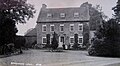 Stanwick Hall C19.jpg 1,551 × 858; 793 KB
-
 Swan on frozen lake - geograph.org.uk - 1140604.jpg 640 × 428; 84 KB
-
 The A45, Higham Ferrers - geograph.org.uk - 5430597.jpg 2,048 × 1,536; 1.51 MB
-
 The A45, Higham Ferrers - geograph.org.uk - 6212947.jpg 1,844 × 1,152; 1.1 MB
-
 The A45, Stanwick - geograph.org.uk - 5431717.jpg 2,048 × 1,536; 1.48 MB
-
 The A45, Stanwick - geograph.org.uk - 5431719.jpg 2,048 × 1,536; 1.53 MB
-
 The Duke Of Wellington, Stanwick - geograph.org.uk - 2543232.jpg 1,496 × 1,122; 625 KB
-
 Wild flowers by the A45, Higham Ferrers - geograph.org.uk - 5430600.jpg 2,048 × 1,536; 1.54 MB
-
 Chelveston Airfield - geograph.org.uk - 228452.jpg 640 × 480; 118 KB
-
 Chelveston Cliffs - geograph.org.uk - 92968.jpg 640 × 480; 81 KB
-
 Chelveston village green - geograph.org.uk - 92957.jpg 640 × 480; 64 KB
-
 Footpath through oil seed rape - geograph.org.uk - 225244.jpg 640 × 480; 88 KB
-
 Stanwick Road - geograph.org.uk - 136294.jpg 640 × 480; 57 KB


_heading_north_-_geograph.org.uk_-_2995416.jpg)


