Category:Starost’s House in Royal Wilanów
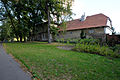
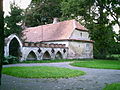
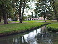
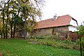
Dom Podstarościego - zarządzającego wilanowskimi dobrami wybudowano w 1850r. Znajduje się on w południowej części Parku angielsko - chińskiego, na granicy dzisiejszego muzeum, na południowym brzegu Potoku Służewieckiego, co sprawia, że od strony parku pałacowego można się tutaj dostać przechodząc przez niewielki mostek ponad potokeim.
The northern front of the "starost's house" is part of the English-Chinese-park, the southern front turns to the former main court/stables of the farm, actually owned by the agriculture university SGGW (and rented to several smaller companies)
| Object location | | View all coordinates using: OpenStreetMap |
|---|
house in Wilanów, Poland  | |||||
| Upload media | |||||
| Instance of | |||||
|---|---|---|---|---|---|
| Location | Wilanów, Warsaw, Masovian Voivodeship, Poland | ||||
| Street address |
| ||||
| Heritage designation |
| ||||
| Inception |
| ||||
 | |||||
Subcategories
This category has only the following subcategory.
Media in category "Starost’s House in Royal Wilanów"
The following 19 files are in this category, out of 19 total.
-
 Starost's house and Potok Służewiecki in Wilanów Park.jpg 5,921 × 3,947; 18.94 MB
-
 Warsaw Wilanow district dom podstarościego, 1850 number 63919 z 1.07.1965.jpg 3,216 × 2,136; 1.78 MB
-
 Warszawa - pałac wilanowski - dom podstarościego - ZJ001.jpg 3,165 × 2,136; 1.45 MB
-
 Warszawa - pałac wilanowski - dom podstarościego - ZJ002.jpg 3,216 × 2,136; 1.64 MB
-
 Wilanów - domu podstarościego - 02.jpg 3,600 × 2,700; 2.1 MB
-
 Wilanów - domu podstarościego - 03.jpg 3,600 × 2,700; 2.33 MB
-
 Wilanów - domu podstarościego - 04.jpg 3,600 × 2,700; 2.36 MB
-
 Wilanów - pałacowy park angielsko - chiński - 02.jpg 2,048 × 1,536; 894 KB
-
 Wilanów DSC 2372.JPG 2,940 × 1,921; 2.18 MB
-
 Wilanów DSC 2373.JPG 2,923 × 1,903; 2.32 MB
-
 Wilanów DSC 2378.JPG 3,008 × 2,000; 2.86 MB
-
 Wilanów DSC 2380.JPG 3,008 × 2,000; 2.92 MB
-
 Wilanów DSC 2381.JPG 3,008 × 2,000; 2.89 MB
-
 Wilanów DSC 2390.JPG 3,008 × 2,000; 2.84 MB
-
 Wilanów farm buildings in park 01.jpg 4,000 × 3,000; 9.01 MB
-
 Wilanów farm buildings in park 03.jpg 4,000 × 3,000; 9.2 MB
-
 Wilanów farm buildings in park 04.jpg 4,000 × 3,000; 9.43 MB
-
 Wilanów farm buildings in park 05.jpg 4,000 × 3,000; 9.18 MB
-
 Zespół pałacowy w Wilanowie - dom podstarościego - ZJ001.jpg 4,288 × 2,848; 2.11 MB


