Category:Station Hemmen-Dodewaard
| Object location | | View all coordinates using: OpenStreetMap |
|---|
railway station in the Netherlands  | |||||
| Upload media | |||||
| Instance of | |||||
|---|---|---|---|---|---|
| Part of | |||||
| Location | Dodewaard, Gelderland, Netherlands | ||||
| Owned by | |||||
| Operator | |||||
| Has part(s) | |||||
| Heritage designation |
| ||||
| Inception |
| ||||
| Date of official opening |
| ||||
| Connecting line | |||||
| Adjacent station | |||||
| official website | |||||
 | |||||
|
This is a category about rijksmonumentcomplex number 512148
|
Stationsgebouw
|
This is a category about rijksmonument number 512149
|
(Fietsen)Berging
|
This is a category about rijksmonument number 512150
|
Voormalig toiletgebouw
|
This is a category about rijksmonument number 512151
|
| Address |
|
Media in category "Station Hemmen-Dodewaard"
The following 20 files are in this category, out of 20 total.
-
 Dodewaard Rijksmonument 512150 fietsenstalling station Hemmen-Dodewaard.JPG 3,648 × 2,736; 4.15 MB
-
 Dodewaard Rijksmonument 512151 toiletgebouwtje station Hemmen-Dodewaard.JPG 3,648 × 2,736; 4.26 MB
-
 HUA-150410-Gezicht op een zijgevel van het N.S.-station te Hemmen-Dodewaard.jpg 3,988 × 2,853; 3.75 MB
-
 HUA-150411-Gezicht op het N.S.-station te Hemmen-Dodewaard.jpg 3,988 × 2,844; 2.86 MB
-
 HUA-153116-Gezicht op de perronzijde van het NS station Hemmen Dodewaard te Hemmen.jpg 3,996 × 2,866; 2.44 MB
-
 HUA-153117-Gezicht op de perronzijde van het NS station Hemmen Dodewaard te Hemmen.jpg 3,999 × 2,853; 3.45 MB
-
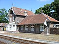
 Station Hemmen-Dodewaard (2024)-1.jpg 4,608 × 3,456; 3.68 MB
-
 Station Hemmen-Dodewaard (2024)-2.jpg 4,608 × 3,456; 4.56 MB
-
 Station Hemmen-Dodewaard (2024)-3.jpg 4,608 × 3,456; 4.6 MB
-
 Station Hemmen-Dodewaard (2024)-4.jpg 4,608 × 3,456; 4.67 MB
-
 Station Hemmen-Dodewaard (2024)-5.jpg 4,608 × 3,456; 5.48 MB
-
 Station Hemmen-Dodewaard (2024)-6.jpg 4,608 × 3,456; 5.15 MB
-
 Station Hemmen-Dodewaard (2024)-7.jpg 4,608 × 3,456; 6.02 MB
-
 Station Hemmen-Dodewaard (2024)-8.jpg 4,608 × 3,456; 5.56 MB
-
 Station Hemmen-Dodewaard1.jpg 1,600 × 1,200; 1.07 MB
-
 Station Hemmen-Dodewaard2.jpg 1,600 × 1,200; 1.23 MB
-
 Station Hemmen-Dodewaard3.jpg 1,200 × 1,600; 620 KB
-
 Station Hemmen-Dodewaard4.jpg 1,489 × 1,162; 771 KB
-
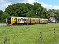 Syntus DM'90 50 Arnhem-Tiel te Hemmen-Dodewaard.jpg 640 × 480; 81 KB
-
 Wachtpost 14 Hemmen-Dodewaard.jpg 1,378 × 896; 495 KB


-1.jpg)
-2.jpg)
-3.jpg)
-4.jpg)
-5.jpg)
-6.jpg)
-7.jpg)
-8.jpg)


