Category:Stegastein
| Camera location | | View all coordinates using: OpenStreetMap |
|---|
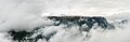
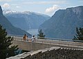
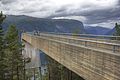
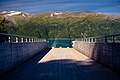
English: Pictures of Stegastein a panorama viewpoint near the municipality Aurland and the Aurlandsfjorden in the county Vestland in Norway
scenic viewpoint in Norway .jpg)  | |||||
| Upload media | |||||
| Instance of | |||||
|---|---|---|---|---|---|
| Location | Aurland Municipality, Vestland, Norway | ||||
| Architect |
| ||||
| Date of official opening |
| ||||
| Width |
| ||||
| Length |
| ||||
| Height |
| ||||
| Elevation above sea level |
| ||||
| official website | |||||
 | |||||
Media in category "Stegastein"
The following 30 files are in this category, out of 30 total.
-
 2023-07-05-Stegastein-6849.jpg 6,720 × 4,480; 15.25 MB
-
 I am afraid of heights - panoramio (1).jpg 3,456 × 2,592; 1.85 MB
-
 I am afraid of heights - panoramio.jpg 2,592 × 1,944; 1.06 MB
-
 Norwegia-79.jpg 2,848 × 4,288; 6.25 MB
-
 Norwegia-82.jpg 4,288 × 2,848; 6.4 MB
-
 Norwegia-83.jpg 4,288 × 2,848; 6.65 MB
-
 Norwegia-84.jpg 2,848 × 4,288; 8.9 MB
-
 Norwegia-85.jpg 4,288 × 2,848; 7.19 MB
-
 Norwegia-86.jpg 4,288 × 2,848; 6.33 MB
-
 Norwegia-87.jpg 4,288 × 2,848; 7.14 MB
-
 Norwegia-88.jpg 4,288 × 2,848; 6.4 MB
-
 Norwegia-90.jpg 2,848 × 4,288; 5.16 MB
-
 Norwegia-92.jpg 4,288 × 2,848; 9.49 MB
-
 Norwegia-93.jpg 4,288 × 2,848; 6.09 MB
-
 P1000461Stegastein.JPG 3,264 × 2,448; 3.71 MB
-
 Shrouded Flenjahornet (31985977288).jpg 9,871 × 3,199; 14.62 MB
-
 Sogn og Fjordane Snövegen - Aurlandsfjord 01.JPG 3,444 × 2,586; 1.52 MB
-
 Stega583B23.jpg 3,850 × 2,472; 1.78 MB
-
 Stegastein Aurlandsfjorden.JPG 1,749 × 1,237; 513 KB
-
 Stegastein In Norwegen.jpg 4,032 × 3,024; 2.63 MB
-
 Stegastein lookout.jpg 2,736 × 3,648; 2.94 MB
-
 Stegastein viewpoint (17413960063).jpg 2,808 × 4,212; 6.19 MB
-
 Stegastein viewpoint - panoramio (1).jpg 5,193 × 3,455; 10.14 MB
-
 Stegastein viewpoint - panoramio.jpg 5,193 × 3,435; 10.49 MB
-
 Stegastein viewpoint showing Aurlandsfjord.jpg 4,032 × 3,024; 1.68 MB
-
 Stegastein viewpoint.jpg 3,968 × 2,976; 4.71 MB
-
 Stegastein.jpg 3,648 × 2,736; 3.14 MB
-
 Stegastein1.jpg 2,592 × 1,728; 712 KB
-
 Stigastein.JPG 2,848 × 2,136; 1.45 MB
-
 View from Stegastein.jpg 3,968 × 2,976; 3.94 MB

.jpg)


.jpg)


.jpg)