Category:Stettfeld
municipality of Germany     | |||||
| Upload media | |||||
| Instance of |
| ||||
|---|---|---|---|---|---|
| Part of |
| ||||
| Location | Haßberge, Lower Franconia, Bavaria, Germany | ||||
| Population |
| ||||
| Area |
| ||||
| Elevation above sea level |
| ||||
| official website | |||||
 | |||||
Subcategories
This category has the following 9 subcategories, out of 9 total.
!
B
M
S
- Silbersandhöhle bei Stettfeld (12 F)
- Stettfelder Mühlbach (12 F)
V
- Views of Stettfeld (3 F)
W
Media in category "Stettfeld"
The following 7 files are in this category, out of 7 total.
-
 DEU Stettfeld COA.svg 557 × 608; 12 KB
-
 Wappen von Stettfeld.png 601 × 640; 95 KB
-
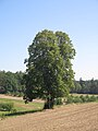 Baum in der Waldabteilung Röderschlag nordwestlich von Stettfeld.jpg 3,000 × 4,000; 3.51 MB
-
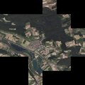 Digitales Orthofoto von Stettfeld (Bayerische Vermessungsverwaltung).tif 15,000 × 15,000; 400.43 MB
-
 See im Erlenlaub südlich von Stettfeld.jpg 7,406 × 3,457; 3.41 MB
-
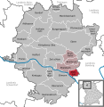 Stettfeld in HAS.svg 567 × 580; 363 KB
-
 Wiese westlich der Silbersandhöhle bei Stettfeld.jpg 6,000 × 4,000; 15.95 MB


