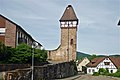
Category:Storchenturm (Gernsbach)
| Object location | | View all coordinates using: OpenStreetMap |
|---|
fortified tower in Gernsbach, Germany  | |||||
| Upload media | |||||
| Instance of | |||||
|---|---|---|---|---|---|
| Location | Gernsbach, Rastatt district, Region Mittlerer Oberrhein, Karlsruhe Government Region, Baden-Württemberg, Germany | ||||
| Heritage designation | |||||
 | |||||
Media in category "Storchenturm (Gernsbach)"
The following 10 files are in this category, out of 10 total.
-
 Gernsbach Storchenturm.jpg 1,704 × 2,272; 617 KB
-
 Gernsbach-20-Storchenturm-gje.jpg 3,456 × 4,646; 3.47 MB
-
 Gernsbach-22-Storchenturm-gje.jpg 3,456 × 5,184; 4.31 MB
-
 Gernsbach-24-Storchenturm-gje.jpg 3,456 × 4,146; 2.99 MB
-
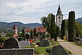 Gernsbach-70-Friedhof-Storchenturm-Kirchturm-gje.jpg 5,184 × 3,456; 3.99 MB
-
 Gernsbach-Liebfrauenkirche-01a-Friedhof-gje.jpg 5,012 × 3,031; 3.15 MB
-
 Gernsbach-Storchenturm (cropped).jpg 784 × 1,224; 411 KB
-
 Gernsbach-Storchenturm.jpg 1,867 × 1,247; 813 KB
-
 Római katolikus templom, Gernsbach.jpg 4,608 × 3,456; 3.55 MB
-
 Storchenturm Gernsbach von Der Bruzzla.jpg 1,186 × 1,600; 629 KB


.jpg)

