Category:Straatweg 200, Breukelen
| Object location | | View all coordinates using: OpenStreetMap |
|---|
building in Stichtse Vecht, Netherlands  | |||||
| Upload media | |||||
| Instance of | |||||
|---|---|---|---|---|---|
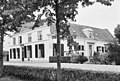
| Location | Breukelen, Utrecht, Netherlands | ||||
| Street address |
| ||||
| Located on street | |||||
| Heritage designation |
| ||||
 | |||||
|
This is a category about rijksmonument number 10620
|
| Address |
|
Media in category "Straatweg 200, Breukelen"
The following 7 files are in this category, out of 7 total.
-
 Breukelen - Straatweg 200-202 RM10620-10621.JPG 4,401 × 3,285; 1.05 MB
-
 Linkerzijgevel - Breukelen - 20042224 - RCE.jpg 1,200 × 957; 277 KB
-
 Overzicht - Breukelen - 20042221 - RCE.jpg 1,200 × 964; 248 KB
-
 Overzicht voorgevels - Breukelen - 20042222 - RCE.jpg 1,200 × 959; 217 KB
-
 Rechterzijgevel - Breukelen - 20042223 - RCE.jpg 1,200 × 954; 239 KB
-
 Voor- en zijgevel - Breukelen - 20042153 - RCE.jpg 1,200 × 807; 287 KB
-
 Zijaanzicht - Breukelen - 20042154 - RCE.jpg 1,200 × 816; 267 KB


