Category:Strijdhoef (Udenhout)
| Object location | | View all coordinates using: OpenStreetMap |
|---|
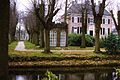
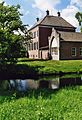
Nederlands: Afbeeldingen van de Strijdhoef (Udenhout), Schoorstraat 14, 5071 RA Udenhout. Gelegen in Udenhout, behorende tot de gemeente Tilburg, in de provincie Noord-Brabant in het zuiden van Nederland. Het is een rijksmonument. Het circa 34 hectare grote landgoed bestaat onder meer uit een landhuis uit 1760. Het landgoed is vrij toegankelijk, afgezien van de onmiddellijke omgeving van het kasteel.
Nederlands: Strijdhoef
|
This is a category about rijksmonumentcomplex number 511886
|
Landhuis
|
This is a category about rijksmonument number 511885
|
Historische aanleg
|
This is a category about rijksmonument number 511887
|
Toegang
|
This is a category about rijksmonument number 511888
|
Tuinkoepel
|
This is a category about rijksmonument number 511889
|
Hekpijlers
|
This is a category about rijksmonument number 511890
|
Tuinbeeld
|
This is a category about rijksmonument number 511891
|
Zonnewijzer
|
This is a category about rijksmonument number 511892
|
IJskelder
|
This is a category about rijksmonument number 511893
|
building in Tilburg, Netherlands  | |||||
| Upload media | |||||
| Instance of | |||||
|---|---|---|---|---|---|
| Part of | |||||
| Location | Udenhout, North Brabant, Netherlands | ||||
| Street address |
| ||||
| Located on street |
| ||||
| Heritage designation |
| ||||
 | |||||
Subcategories
This category has only the following subcategory.
I
Media in category "Strijdhoef (Udenhout)"
The following 10 files are in this category, out of 10 total.
-
 Gemetselde ingangspoort met kantelen - Udenhout - 20210964 - RCE.jpg 1,200 × 960; 408 KB
-
 Strijdhoef 2.jpg 3,008 × 2,000; 6.05 MB
-
 Strijdhoef beeld.jpg 628 × 707; 142 KB
-
 Strijdhoef koepel.jpg 1,483 × 987; 411 KB
-
 Strijdhoef poort.jpg 1,523 × 984; 360 KB
-
 Strijdhoef Udenhout.jpg 1,482 × 2,160; 684 KB
-
 Theekoepel - Udenhout - 20210968 - RCE.jpg 961 × 1,200; 412 KB
-
 Tuinbeeld - Udenhout - 20210967 - RCE.jpg 1,200 × 943; 389 KB
-
 Voor- en zijgevel - Udenhout - 20210966 - RCE.jpg 1,200 × 960; 338 KB
-
 Voorzijde - Udenhout - 20210965 - RCE.jpg 1,200 × 961; 320 KB


