Category:Styresholm
| Object location | | View all coordinates using: OpenStreetMap |
|---|
 | |||||
| Upload media | |||||
| Instance of | |||||
|---|---|---|---|---|---|
| Location | Q10700450, Kramfors Municipality, Västernorrland County, Sweden | ||||
| Heritage designation |
| ||||
 | |||||
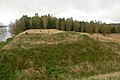
Svenska: Fästningen/skansen Styresholm i Kramfors kommun.
English: Styresholm, ruins of a 14-century fortification
|
This is a category about an archaeological site or a monument in Sweden, number Torsåker 17:1 in the RAÄ Fornsök database. |
Media in category "Styresholm"
The following 7 files are in this category, out of 7 total.
-
 Styresholm RAÄ 1.jpg 732 × 495; 74 KB
-
 Styresholm RAÄ 2.jpg 735 × 494; 84 KB
-
 Torsåker 17 - 1 (2).JPG 4,608 × 3,072; 6.85 MB
-
 Torsåker 17 - 1 (3).JPG 3,072 × 4,608; 4.71 MB
-
 Torsåker 17 - 1 (4).JPG 4,608 × 3,072; 4.69 MB
-
 Torsåker 17 - 2.JPG 3,072 × 4,608; 6 MB
-
 Torsåker 17-1.JPG 4,608 × 3,072; 6.26 MB

.JPG)
.JPG)
.JPG)

