Category:Sunday School of St Andrew's Church, Rodney Street
| Object location | | View all coordinates using: OpenStreetMap |
|---|
This is a category about listed building number 1072946. |
building in Liverpool, Merseyside, England, UK  | |||||
| Upload media | |||||
| Instance of | |||||
|---|---|---|---|---|---|
| Location | Liverpool, Merseyside, North West England, England | ||||
| Heritage designation |
| ||||
 | |||||
Grade II listed former Sunday School of adjacent church, restored c. 2013.
Media in category "Sunday School of St Andrew's Church, Rodney Street"
The following 2 files are in this category, out of 2 total.
-
 Renovation at the Church of Saint Andrew, Liverpool (6).JPG 4,608 × 3,456; 3.71 MB
-
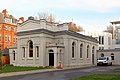 Sunday School of St Andrew's Church, Rodney Street.jpg 4,686 × 3,138; 11.42 MB
.JPG)