Category:Synagoge, Arnhem
| Object location | | View all coordinates using: OpenStreetMap |
|---|
 | |||||
| Upload media | |||||
| Instance of | |||||
|---|---|---|---|---|---|
| Location | Arnhem, Gelderland, Netherlands | ||||
| Street address |
| ||||
| Located on street |
| ||||
| Heritage designation |
| ||||
 | |||||
|
This is a category about rijksmonument number 8357
|
| Address |
|
Subcategories
This category has only the following subcategory.
R
- Restoration of Synagoge, Arnhem (12 F)
Media in category "Synagoge, Arnhem"
The following 37 files are in this category, out of 37 total.
-
 Arke met voorhangsel - Arnhem - 20024958 - RCE.jpg 960 × 1,200; 226 KB
-
 Arke op galerij - Arnhem - 20024963 - RCE.jpg 958 × 1,200; 277 KB
-
 Arke op galerij - Arnhem - 20024965 - RCE.jpg 960 × 1,200; 180 KB
-
 Arke, geopend - Arnhem - 20024959 - RCE.jpg 962 × 1,200; 214 KB
-
 Arke, zonder voorhangsel gesloten - Arnhem - 20024957 - RCE.jpg 960 × 1,200; 225 KB
-
 Arnhem - Pastoorstraat 17A - bordje.jpg 2,592 × 1,944; 1.71 MB
-
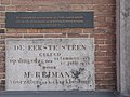 Arnhem - Pastoorstraat 17A - plaquette.jpg 2,592 × 1,944; 1.78 MB
-
 Arnhem - Pastoorstraat 17A.jpg 2,592 × 1,944; 1.47 MB
-
 Arnhem2023Synagogue.jpg 2,448 × 3,264; 2.71 MB
-
 Besnijdenisbank - Arnhem - 20024966 - RCE.jpg 957 × 1,200; 179 KB
-

-

-

-
 De synagoge te Arnhem gezien vanaf de straat - Arnhem - 20365179 - RCE.jpg 1,200 × 926; 179 KB
-
 De synagoge te Arnhem gezien vanaf de straat - Arnhem - 20365183 - RCE.jpg 1,133 × 1,200; 265 KB
-
-
 Exterieur OVERZICHT VOORGEVEL - Arnhem - 20264059 - RCE.jpg 924 × 1,200; 200 KB
-

-

-
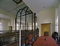
 Huidige interieur - Arnhem - 20024961 - RCE.jpg 960 × 1,200; 183 KB
-
 Interieur - Arnhem - 20024954 - RCE.jpg 1,200 × 801; 178 KB
-
 INTERIEUR, ARKE - Arnhem - 20260522 - RCE.jpg 1,200 × 960; 181 KB
-

-
 Kastje met wetsrol in de loofhut - Arnhem - 20024962 - RCE.jpg 960 × 1,200; 200 KB
-
 Kastje met wetsrol in de loofhut - Arnhem - 20024964 - RCE.jpg 964 × 1,200; 192 KB
-

-
 Kroonluchter in de synagoge te Arnhem - Arnhem - 20365180 - RCE.jpg 790 × 1,200; 135 KB
-
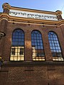
 Pastoorstraat 17, voorgevel - Arnhem - 20025545 - RCE.jpg 802 × 1,200; 168 KB
-
 Pastoorstraat 17-17a, overzicht - Arnhem - 20025543 - RCE.jpg 807 × 1,200; 178 KB
-
 Pastoorstraat 17a, aanzicht exterieur - Arnhem - 20024953 - RCE.jpg 804 × 1,200; 164 KB
-
 Pastoorstraat 17a, gevel - Arnhem - 20025544 - RCE.jpg 813 × 1,200; 182 KB
-
 Reproductie oude interieur - Arnhem - 20024968 - RCE.jpg 1,200 × 967; 319 KB
-
 Reproductie van oude interieur - Arnhem - 20024969 - RCE.jpg 1,200 × 956; 227 KB
-
 Reproductie verenigingsgebouw - Arnhem - 20024955 - RCE.jpg 956 × 1,200; 249 KB
-
 Reproductie voormalige badhuis - Arnhem - 20024956 - RCE.jpg 953 × 1,200; 219 KB
-
 Wetsrollen in arke - Arnhem - 20024960 - RCE.jpg 959 × 1,200; 252 KB
-
 Zijgevel van de synagoge te Arnhem - Arnhem - 20365178 - RCE.jpg 926 × 1,200; 231 KB


_-_Arnhem_-_20365174_-_RCE.jpg)


_en_aan_de_achterzijde_de_Heilige_Arke_met_rechts_een_negenarmige_kandelaar_(Chanoekia)_-_Arnhem_-_20365166_-_RCE.jpg)
_en_in_het_midden_een_glazen_wand_-_Arnhem_-_20365177_-_RCE.jpg)


