Category:Synagoge Charlottenburg
| Object location | | View all coordinates using: OpenStreetMap |
|---|
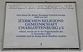
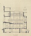
Deutsch: Die Synagoge Charlottenburg in der damaligen Schulstraße 7 (heute Behaimstr. 11), Berlin-Charlottenburg, ließ die Jüdische Religionsgemeinschaft Charlottenburg errichten und weihte sie am 30.3.1890 ein. 1937 übernahm die Jüdische Gemeinde zu Berlin den Bau. Im Novemberpogrom 1938 wurde die Synagoge geplündert und verwüstet. Der Bau wurde 1943 im Luftkrieg zerstört und die Ruine 1957 abgetragen.
English: The Charlottenburg Synagogue on then Schulstraße 7 (now renamed and renumbered Behaimstraße 11) was erected by the Jewish congregation Jüdische Religionsgemeinschaft Charlottenburg and inaugurated on 30 March 1890. In 1937 the Jewish congregation Jüdische Gemeinde zu Berlin adopted the synagogue. It was looted and badly damaged in the night of the November Pogrom in 1938. The building was destroyed in an Allied air raid in 1943 and its ruin removed in 1957.
 | |||||
| Upload media | |||||
| Instance of | |||||
|---|---|---|---|---|---|
| Location |
| ||||
| Architectural style | |||||
| Dissolved, abolished or demolished date |
| ||||
 | |||||
Media in category "Synagoge Charlottenburg"
The following 7 files are in this category, out of 7 total.
-
 Berlin GTafel Juedisch.jpg 1,470 × 930; 164 KB
-
 Berlin-Charlottenburg, Synagoge Schulstraße, Grundriss Erdgeschoss.jpg 539 × 800; 254 KB
-
 Berlin-Charlottenburg, Synagoge Schulstraße, Entwurf Fassade.jpg 596 × 800; 258 KB
-
 Berlin-Charlottenburg, Synagoge Schulstraße, Längsschnitt.jpg 682 × 800; 207 KB
-
 Charlottenburg Synagoge Schulstraße 7 Entwurf.jpg 1,245 × 1,030; 1.08 MB
-
 Charlottenburg Synagoge Schulstraße 7.jpg 624 × 856; 518 KB
-
 Gedenktafel Behaimstr 11 (Charl) Synagoge Charlottenburg.JPG 1,925 × 1,393; 3.66 MB


_Synagoge_Charlottenburg.JPG)