Category:Türkenfeld
municipality of Germany    | |||||
| Upload media | |||||
| Pronunciation audio | |||||
|---|---|---|---|---|---|
| Instance of |
| ||||
| Part of |
| ||||
| Location | Fürstenfeldbruck, Upper Bavaria, Bavaria, Germany | ||||
| Head of government |
| ||||
| Population |
| ||||
| Area |
| ||||
| Elevation above sea level |
| ||||
| official website | |||||
 | |||||
Subcategories
This category has the following 4 subcategories, out of 4 total.
Media in category "Türkenfeld"
The following 6 files are in this category, out of 6 total.
-
 Geltendorf-1985.jpg 1,280 × 867; 190 KB
-
 Tuerkenfeld in ffb.svg 435 × 330; 103 KB
-
 Türkenfeld in FFB.svg 446 × 390; 976 KB
-
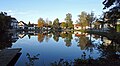 Türkenfeld, FFB - Dorfweiher v W.jpg 4,517 × 2,481; 831 KB
-
 Tfeld 150.gif 482 × 523; 28 KB
-
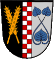
 Tuerkenfeld Wappen.svg 482 × 523; 39 KB


