Category:Tackley
village and civil parish in West Oxfordshire, England  | |||||
| Upload media | |||||
| Instance of | |||||
|---|---|---|---|---|---|
| Location | West Oxfordshire, Oxfordshire, South East England, England | ||||
| Population |
| ||||
| official website | |||||
 | |||||
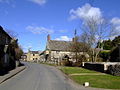
English: Tackley is a village and civil parish beside the River Cherwell in Oxfordshire, England. It is about north of Kidlington. The village consists of two neighbourhoods: Tackley itself, and Nethercott.
Subcategories
This category has the following 2 subcategories, out of 2 total.
T
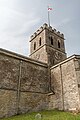
- St Nicholas' Church, Tackley (12 F)
- Tackley railway station (11 F)
Media in category "Tackley"
The following 200 files are in this category, out of 221 total.
(previous page) (next page)-
 'Danger failed road' - geograph.org.uk - 5192689.jpg 640 × 480; 323 KB
-
 1740 to Oxford at Tackley - geograph.org.uk - 4712337.jpg 1,280 × 869; 287 KB
-
 A4260 by Old Man Leys - geograph.org.uk - 2689800.jpg 3,541 × 2,556; 1.11 MB
-
 A4260 north of Sturdy's Castle - geograph.org.uk - 2689006.jpg 3,459 × 2,212; 949 KB
-
 A4260 northwest of Tackley - geograph.org.uk - 2689353.jpg 3,437 × 2,475; 1.14 MB
-
 A4260 south of Sturdy's Castle - geograph.org.uk - 2688991.jpg 3,448 × 2,409; 1,003 KB
-
 A4260.jpg 3,456 × 2,304; 424 KB
-

-
 Angelinos (Woodstock) Pumping Station - geograph.org.uk - 4215941.jpg 1,024 × 683; 291 KB
-
 Arch through Northbrook Bridge - geograph.org.uk - 4520768.jpg 828 × 1,024; 297 KB
-
 Bakers Lock - Oxford Canal - geograph.org.uk - 96447.jpg 640 × 480; 198 KB
-
 Ball Lane, Tackley, Kidlington, Oxfordshire - geograph.org.uk - 4992637.jpg 700 × 1,050; 1.16 MB
-
 Banbury Road by Rousham Gap - geograph.org.uk - 4057818.jpg 1,500 × 999; 171 KB
-
 Banbury Road to Deddington - geograph.org.uk - 4049340.jpg 1,500 × 999; 101 KB
-
 Banbury Road to Deddington - geograph.org.uk - 4057807.jpg 1,500 × 999; 132 KB
-
 Banbury Road to Deddington - geograph.org.uk - 4057811.jpg 1,500 × 999; 156 KB
-
 Banbury Road to Deddington - geograph.org.uk - 4057817.jpg 1,500 × 999; 109 KB
-
 Banbury Road to Woodstock - geograph.org.uk - 6181431.jpg 2,700 × 2,025; 435 KB
-
 Banbury Road to Woodstock - geograph.org.uk - 6181434.jpg 2,700 × 2,025; 316 KB
-
 Banbury Road, Tackley - geograph.org.uk - 6078425.jpg 1,860 × 1,239; 1.08 MB
-
 Beefy's Snacks in the lay by - geograph.org.uk - 4105008.jpg 3,372 × 2,176; 2.03 MB
-
 Benchmark and plaque on the Old School House - geograph.org.uk - 3203895.jpg 683 × 1,024; 204 KB
-
 Benchmark on bus shelter, Rousham Road - geograph.org.uk - 3203945.jpg 683 × 1,024; 291 KB
-

-

-
 Benchmark on St Nicholas Church - geograph.org.uk - 3204081.jpg 683 × 1,024; 296 KB
-
 Benchmark on ^50 Nethercote Road - geograph.org.uk - 3204051.jpg 683 × 1,024; 228 KB
-
 Bridge over branch of River Cherwell - geograph.org.uk - 5660890.jpg 1,024 × 683; 265 KB
-

-
 Bridleway crossing at Tackley Station - geograph.org.uk - 4712338.jpg 1,280 × 960; 320 KB
-
 BT Telephone Exchange near Tackley - geograph.org.uk - 3204159.jpg 1,024 × 683; 125 KB
-
 Buildings at Old Whitehill Barn - geograph.org.uk - 3204899.jpg 1,024 × 683; 168 KB
-
 Bungalow at Old Weaveley Farm - geograph.org.uk - 4217450.jpg 1,024 × 683; 191 KB
-
 Bus stop shelter on Rousham Road - geograph.org.uk - 3203955.jpg 1,024 × 683; 214 KB
-

-

-

-
-

-
 Church Hill Tackley - geograph.org.uk - 2941709.jpg 506 × 640; 116 KB
-

-

-

-
 Cottages in Tackley - geograph.org.uk - 3367413.jpg 1,200 × 803; 1.09 MB
-
 Country lane at Pound Hill - geograph.org.uk - 4522660.jpg 1,024 × 661; 165 KB
-
 Country lane near Lower Whitehill Farm - geograph.org.uk - 4522649.jpg 1,024 × 735; 211 KB
-
 Cows, Tackley, Kidlington, Oxfordshire - geograph.org.uk - 4992930.jpg 1,400 × 933; 1.68 MB
-

-
 Crossovers at Tackley - geograph.org.uk - 1324818.jpg 640 × 427; 90 KB
-

-

-
 Decorated cross on The Green - geograph.org.uk - 3950152.jpg 988 × 1,500; 344 KB
-
 Ditch in field west of Northbrook Bridge - geograph.org.uk - 6101843.jpg 1,024 × 683; 262 KB
-
 Enslow Bridge - geograph.org.uk - 4712293.jpg 1,280 × 960; 372 KB
-

-

-
 Farmland in the Cherwell valley - geograph.org.uk - 4522695.jpg 1,024 × 731; 239 KB
-
 Farmland north of Woodstock - geograph.org.uk - 4421008.jpg 2,592 × 1,944; 1.3 MB
-
 Field Barn Farm - geograph.org.uk - 4105020.jpg 640 × 480; 88 KB
-
 Field Cottage, Whitehill.jpg 3,456 × 2,304; 2.51 MB
-
 Field footpath heading for the road and Thackley Park - geograph.org.uk - 5596667.jpg 4,000 × 3,000; 5.13 MB
-
 Field view from Tacknell Triangulation Pillar - geograph.org.uk - 5596658.jpg 4,000 × 3,000; 4.13 MB
-
 Fields near Tackley - geograph.org.uk - 2565361.jpg 640 × 480; 80 KB
-

-

-

-
 Footpath through a wheat field - geograph.org.uk - 4105015.jpg 4,000 × 3,000; 3.82 MB
-

-
 Footpath through rape - geograph.org.uk - 417910.jpg 640 × 480; 133 KB
-

-
 Gate to Whitehill Earth Station - geograph.org.uk - 4105023.jpg 3,616 × 2,848; 2.67 MB
-
 Gated track into Old Weaveley Farm - geograph.org.uk - 4215957.jpg 1,024 × 683; 282 KB
-

-

-

-

-

-

-

-

-
 House at Old Weaveley Farm - geograph.org.uk - 4217446.jpg 1,024 × 683; 254 KB
-
 House, Tackley, Kidlington, Oxfordshire - geograph.org.uk - 4992933.jpg 1,400 × 933; 1.3 MB
-

-
 Houses on the Green, Tackley - geograph.org.uk - 5192695.jpg 640 × 480; 194 KB
-

-

-

-

-
 Letchmere Cottage along Tackley Road - geograph.org.uk - 4522833.jpg 1,024 × 712; 281 KB
-
 Little Whitehill railway bridge - geograph.org.uk - 3204929.jpg 683 × 1,024; 205 KB
-
 Looking north along Banbury Road - geograph.org.uk - 4217161.jpg 1,024 × 683; 213 KB
-

-
 Making a new driveway - geograph.org.uk - 4105124.jpg 3,828 × 2,668; 2.91 MB
-
-
 Narrow lane at Pound Hill - geograph.org.uk - 4522707.jpg 1,024 × 768; 242 KB
-
 Nethercot Road, Tackley - geograph.org.uk - 386097.jpg 640 × 425; 187 KB
-
 Nethercote Road, Tackley - geograph.org.uk - 4712332.jpg 1,280 × 960; 270 KB
-
 Nethercote Road, Tackley - geograph.org.uk - 4712334.jpg 1,280 × 962; 294 KB
-
 Northbrook Bridge crossing the River Cherwell - geograph.org.uk - 4520758.jpg 1,024 × 785; 340 KB
-
 Old Whitehill House - geograph.org.uk - 3204858.jpg 1,024 × 683; 193 KB
-
 Open country west of Kirtlington - geograph.org.uk - 2038964.jpg 640 × 427; 72 KB
-

-
 Oxford Canal - geograph.org.uk - 125257.jpg 640 × 480; 76 KB
-
 Oxford Canal - geograph.org.uk - 125264.jpg 640 × 480; 77 KB
-
 Oxford Canal - geograph.org.uk - 1598651.jpg 640 × 480; 65 KB
-
 Oxfordshire Way - geograph.org.uk - 2689277.jpg 640 × 480; 100 KB
-
 Oxfordshire Way - geograph.org.uk - 2689283.jpg 640 × 480; 75 KB
-
 Oxfordshire Way - geograph.org.uk - 2689287.jpg 640 × 480; 69 KB
-
 Oxfordshire Way footpath - geograph.org.uk - 2038869.jpg 640 × 427; 82 KB
-

-

-

-

-

-
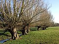 Pollard willows near the canal - geograph.org.uk - 1772198.jpg 800 × 600; 148 KB
-
 Pound Hill near Tackley - geograph.org.uk - 4198169.jpg 1,500 × 999; 187 KB
-

-
 Railway bridge near Pound Hill - geograph.org.uk - 4522720.jpg 1,024 × 768; 296 KB
-

-

-

-

-
 Red Kite, The Old Barn, Tackley, Kidlington, Oxfordshire - geograph.org.uk - 4992970.jpg 1,400 × 1,013; 944 KB
-

-

-
 Ridge and furrow at Pound Hill - geograph.org.uk - 1772523.jpg 800 × 600; 120 KB
-
 River Cherwell west of Kirtlington - geograph.org.uk - 2038924.jpg 640 × 427; 114 KB
-
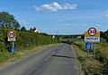
 Road from Tackley joins the A4260 - geograph.org.uk - 2565362.jpg 640 × 480; 74 KB
-
 Rose Cottage - geograph.org.uk - 3367408.jpg 1,200 × 800; 1.13 MB
-
 Rose Cottage in Tackley - geograph.org.uk - 4522753.jpg 1,024 × 749; 200 KB
-
 Rousham Road in Tackley - geograph.org.uk - 4522760.jpg 1,024 × 775; 283 KB
-
 Rousham Road in Tackley - geograph.org.uk - 4522771.jpg 1,024 × 717; 170 KB
-
 Rural road to Bunkers Hill - geograph.org.uk - 4198168.jpg 1,500 × 999; 187 KB
-
 Rural road to Tackley - geograph.org.uk - 4198171.jpg 1,500 × 999; 224 KB
-
 Sansom's Lane, bridleway - geograph.org.uk - 2639253.jpg 640 × 480; 122 KB
-
 Sansoms Lane near Wootton - geograph.org.uk - 6373405.jpg 1,920 × 1,280; 2.51 MB
-
 Sansoms Platt - geograph.org.uk - 4114834.jpg 4,000 × 3,000; 3.94 MB
-
 Satellite dish at Whitehill Earth Station - geograph.org.uk - 3642584.jpg 4,320 × 3,240; 5.17 MB
-
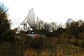 Satellite dish at Whitehill Earth Station - geograph.org.uk - 3843945.jpg 1,500 × 999; 153 KB
-
 Satellite Earth Station - geograph.org.uk - 1040904.jpg 640 × 480; 70 KB
-

-
 Satellite Earth Station, Enslow - geograph.org.uk - 634352.jpg 640 × 480; 86 KB
-
 Schizophrenic road north of Sturdy's Castle - geograph.org.uk - 2689752.jpg 3,397 × 2,434; 1.08 MB
-
 Sewage treatment works near Tackley - geograph.org.uk - 1772207.jpg 800 × 600; 155 KB
-
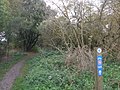 Sign for National Cycle Route 5 - geograph.org.uk - 2639267.jpg 640 × 480; 130 KB
-
 Slopes of Pound Hill - geograph.org.uk - 5192693.jpg 640 × 480; 167 KB
-
 South along Rousham Road towards Tackley - geograph.org.uk - 4522790.jpg 1,024 × 768; 228 KB
-
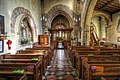
 St Nicholas Church - geograph.org.uk - 3204102.jpg 1,024 × 683; 171 KB
-
 St Nicholas Church in Tackley - geograph.org.uk - 3950135.jpg 1,500 × 999; 194 KB
-
 St Nicholas Church Tackley, Kidlington, Oxfordshire - geograph.org.uk - 4992938.jpg 1,400 × 933; 1.43 MB
-

-
 St Nicholas Church, Tackley, Kidlington, Oxfordshire - geograph.org.uk - 4992926.jpg 1,400 × 933; 1.63 MB
-
 St Nicholas Church, Tackley, Kidlington, Oxfordshire - geograph.org.uk - 4992927.jpg 1,400 × 933; 1.46 MB
-

-
 Staggered junction on the B4027 at Banbury Road - geograph.org.uk - 6373403.jpg 1,856 × 1,174; 1.06 MB
-
 Staggered junction on the B4027 at Banbury Road - geograph.org.uk - 6373404.jpg 1,920 × 1,280; 1.11 MB
-
 Stone Stile - geograph.org.uk - 2941666.jpg 640 × 474; 144 KB
-
 Sturdy's Castle - geograph.org.uk - 4698623.jpg 3,102 × 1,992; 1.18 MB
-
 Sturdy's Castle hotel, rear courtyard - geograph.org.uk - 4698619.jpg 3,264 × 2,448; 2.31 MB
-
 Sturdy's Castle near Tackley - geograph.org.uk - 3615359.jpg 1,500 × 985; 206 KB
-
 Sturdy's Castle Public House - geograph.org.uk - 386084.jpg 640 × 425; 184 KB
-
 Sturdy's Castle, Oxford - panoramio.jpg 4,608 × 3,456; 3.16 MB
-
 Tackley Church (6307061612).jpg 4,255 × 2,830; 1.52 MB
-
 Tackley Church - geograph.org.uk - 2565358.jpg 640 × 502; 81 KB
-
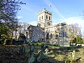 Tackley church - geograph.org.uk - 5195075.jpg 640 × 480; 231 KB
-
 Tackley Gas Pressure Reducing Station - geograph.org.uk - 321135.jpg 640 × 480; 135 KB
-
 Tackley in 2006.jpg 640 × 480; 87 KB
-

-
 Tackley railway station, Oxfordshire - geograph.org.uk - 4043210.jpg 1,024 × 768; 229 KB
-
 Tackley Road to Rousham - geograph.org.uk - 3950177.jpg 1,500 × 999; 106 KB
-
 Tackley Road to Rousham - geograph.org.uk - 3950182.jpg 1,500 × 999; 114 KB
-
 Tackley station - geograph.org.uk - 5192699.jpg 640 × 480; 165 KB
-
 Tackley SturdysCastle.JPG 2,970 × 1,480; 1.52 MB
-
 Tackley VillageHall 1.jpg 3,000 × 1,800; 1.14 MB
-
 Tackley VillageHall 2.jpg 3,000 × 1,800; 1.4 MB
-
 Tackley Woods - geograph.org.uk - 5192710.jpg 640 × 480; 182 KB
-
 Terraced cottages on The Green - geograph.org.uk - 3950155.jpg 1,500 × 999; 202 KB
-
 Thatched cottage at Tackley - geograph.org.uk - 4712331.jpg 1,280 × 960; 298 KB
-
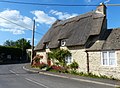
 Thatched cottage in Tackley - geograph.org.uk - 2565353.jpg 640 × 480; 100 KB
-
 The B4027 near Wootton - geograph.org.uk - 6373406.jpg 1,920 × 1,280; 1.68 MB
-
 The B4027 near Wootton - geograph.org.uk - 6373407.jpg 1,920 × 1,280; 1.4 MB
-
 The former Kings Arms on Nethercote Road - geograph.org.uk - 4198174.jpg 1,500 × 999; 148 KB
-
 The Gardiner Arms on Medcroft Road - geograph.org.uk - 3950159.jpg 1,500 × 999; 265 KB
-
 The Green in Tackley - geograph.org.uk - 3950149.jpg 1,500 × 999; 256 KB
-
 The lych gate to St Nicholas Church - geograph.org.uk - 3950140.jpg 999 × 1,500; 158 KB
-
 The new entrance to Sturdy's Castle - geograph.org.uk - 3615360.jpg 1,500 × 886; 181 KB
-
 The Old Barn, Tackley, Kidlington, Oxfordshire - geograph.org.uk - 4992631.jpg 1,400 × 933; 1.26 MB
-
 The Old Barn, Tackley, Kidlington, Oxfordshire - geograph.org.uk - 4992968.jpg 1,400 × 933; 1.4 MB
-
 The Oxfordshire Way near Tackley - geograph.org.uk - 4198173.jpg 1,500 × 999; 323 KB
-
 The River Cherwell in flood - geograph.org.uk - 3843952.jpg 1,500 × 999; 149 KB
-
 The River Cherwell near Northbrook Bridge - geograph.org.uk - 4520753.jpg 1,024 × 768; 318 KB
-
 The road to Tackley - geograph.org.uk - 4421016.jpg 2,592 × 1,944; 1.61 MB
-
 The road to Whitehill Farm from Pound Hill - geograph.org.uk - 3204884.jpg 683 × 1,024; 161 KB
-
 The Satellite Earth Station - geograph.org.uk - 305969.jpg 640 × 480; 92 KB
-
 To Wootton and Glympton - geograph.org.uk - 4105030.jpg 3,856 × 2,836; 2.31 MB
-
-
 Track to the River Cherwell and Tackley Station - geograph.org.uk - 4522734.jpg 1,024 × 768; 257 KB
-
 Twilight at Tackley - geograph.org.uk - 4712335.jpg 960 × 1,280; 255 KB
-
 View across the Cherwell valley - geograph.org.uk - 4522813.jpg 1,024 × 793; 311 KB
-
 View north-east from Tackley Road - geograph.org.uk - 5192715.jpg 640 × 480; 138 KB


_Pumping_Station_-_geograph.org.uk_-_4215941.jpg)


.jpg)


