Category:Taggenberg
 | |||||
| Upload media | |||||
| Instance of |
| ||||
|---|---|---|---|---|---|
| Location |
| ||||
| Area |
| ||||
| Elevation above sea level |
| ||||
 | |||||
Media in category "Taggenberg"
The following 13 files are in this category, out of 13 total.
-
 Karte Winterthur Quartiere Taggenberg.png 1,181 × 1,088; 488 KB
-
 Karte Winterthur Taggenberg.svg 1,911 × 2,058; 4.53 MB
-
 Restaurant Sporrer, Wülflingen - panoramio.jpg 2,568 × 1,047; 1.21 MB
-
 Restaurant Taggenberg.JPG 1,280 × 960; 482 KB
-
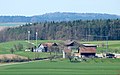
 Taggenberg 2022.jpeg 3,812 × 2,408; 1.51 MB
-
 Taggenberg Januar20-1.jpeg 4,016 × 2,473; 1.83 MB
-
 Taggenberg Januar20-2.jpeg 3,949 × 2,269; 1.74 MB
-
 Taggenberg Januar20-3.jpeg 4,005 × 2,629; 2.39 MB
-
 Taggenberg Januar20-4.jpeg 3,599 × 2,699; 4.79 MB
-
 Taggenberg Januar20-5.jpeg 4,032 × 3,024; 3.71 MB
-
 Taggenberg Restaurant Januar20.jpeg 4,032 × 3,024; 1.92 MB
-
 Taggenberg.jpg 3,927 × 2,453; 1.89 MB
-
 Windpark Taggenberg GWh 2002 2015.png 697 × 389; 8 KB


