Category:Taghadoe
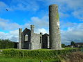
Early monastic foundation:

|
This object is indexed in the Archaeological Survey of Ireland under SMR No. KD010-014----
Geographic information system of the National Monuments Service: Historic Environment Viewer – Database record. |
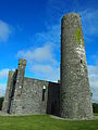
Round tower:
|
|
This object is indexed in the Archaeological Survey of Ireland under SMR No. KD010-014002-
Geographic information system of the National Monuments Service: Historic Environment Viewer – Database record. |
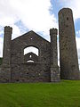
Ruins of 1821 church:
|
|
This object is indexed in the Archaeological Survey of Ireland under SMR No. KD010-014005-
Geographic information system of the National Monuments Service: Historic Environment Viewer – Database record. |
monastery in Republic of Ireland  | |||||
| Upload media | |||||
| Instance of | |||||
|---|---|---|---|---|---|
| Location | County Kildare, Leinster, Ireland | ||||
| Has part(s) | |||||
 | |||||
Media in category "Taghadoe"
The following 28 files are in this category, out of 28 total.
-
 01. Taghadoe Church and Round Tower.jpg 2,448 × 3,264; 2.21 MB
-
 02. Taghadoe Church and Round Tower.jpg 2,448 × 3,264; 2.14 MB
-
 03. Taghadoe Church and Round Tower.jpg 3,264 × 2,448; 3.31 MB
-
 04. Taghadoe Church and Round Tower.jpg 2,448 × 3,264; 3.4 MB
-
 05. Taghadoe Church and Round Tower.jpg 2,448 × 3,264; 3.45 MB
-
 06. Taghadoe Church and Round Tower.jpg 3,264 × 2,448; 3.5 MB
-
 07. Taghadoe Church and Round Tower.jpg 3,264 × 2,448; 3.51 MB
-
 09. Taghadoe Church and Round Tower.jpg 2,448 × 3,264; 2.99 MB
-
 11. Taghadoe Church and Round Tower.jpg 3,264 × 2,448; 2 MB
-
 12. Taghadoe Church and Round Tower.jpg 3,264 × 2,448; 2.16 MB
-
 13. Taghadoe Church and Round Tower.jpg 2,448 × 3,264; 2.56 MB
-
 14. Taghadoe Church and Round Tower.jpg 3,264 × 2,448; 2.38 MB
-
 ESB Power station on the Straffan Road - geograph.org.uk - 3282001.jpg 1,024 × 682; 91 KB
-
 Taghadoe Church 1.jpg 4,948 × 3,280; 8.42 MB
-
 Taghadoe Church 2.jpg 3,280 × 4,948; 9.07 MB
-
 Taghadoe Irish Round Tower County Kildare.jpg 4,048 × 3,040; 1.88 MB
-
 Taghadoe Round Tower & Church 1.JPG 3,024 × 4,032; 2.79 MB
-
 Taghadoe Round Tower & Church 2.JPG 3,024 × 4,032; 2.61 MB
-
 Taghadoe Round Tower & Church 3.JPG 4,032 × 3,024; 2.74 MB
-
 Taghadoe Round Tower & Church 4.JPG 4,032 × 3,024; 2.6 MB
-
 Taghadoe Round Tower & Church 5.JPG 4,032 × 3,024; 2.32 MB
-
 Taghadoe Round Tower - geograph.org.uk - 3310151.jpg 1,020 × 787; 327 KB
-
 Taghadoe Round Tower and Church.jpg 2,592 × 1,944; 1.02 MB
-
 Taghadoe Round Tower Church 1.jpg 1,365 × 2,048; 460 KB
-
 Taghadoe Round Tower Church 2.jpg 1,365 × 2,048; 224 KB
-
 Taghadoe Round Tower Church 3.jpg 1,365 × 2,048; 534 KB
-
 Taghadoe Round Tower Church 4.jpg 1,365 × 2,048; 493 KB
-
 Taghadoe Round Tower Church 5.jpg 1,365 × 2,048; 369 KB


