Category:Talhenbont
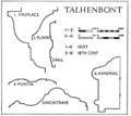
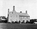
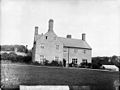
Grade II listed building in Gwynedd. The house, until recently known as Plas Hen, stands N of Llanystumdwy and is reached by a driveway leading off the road running NE from Chwilog in the direction of Rhoslan.  | |||||
| Upload media | |||||
| Instance of | |||||
|---|---|---|---|---|---|
| Part of |
| ||||
| Location |
| ||||
| Heritage designation | |||||
| Elevation above sea level |
| ||||
 | |||||
Media in category "Talhenbont"
The following 19 files are in this category, out of 19 total.
-
 Architecture of Talhenbont Hall.png 353 × 323; 43 KB
-
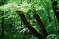 Coed Talhenbont Woods - geograph.org.uk - 802612.jpg 640 × 428; 150 KB
-
 Heathland near Talhenbont Hall - geograph.org.uk - 1765000.jpg 1,024 × 794; 427 KB
-
 Plas Hen Farm - geograph.org.uk - 1765002.jpg 1,024 × 768; 223 KB
-
 Plas Hen, Llanystumdwy NLW3363019.jpg 591 × 424; 40 KB
-
 Plas Hen, Talhenbont, Llanystumdwy NLW3362127 (cropped).jpg 487 × 384; 46 KB
-
 Plas Hen, Talhenbont, Llanystumdwy NLW3362127.jpg 592 × 446; 47 KB
-
 Talhenbont entrance.jpg 2,016 × 1,512; 1.1 MB
-
 Talhenbont Hall floor plan.png 355 × 302; 66 KB
-
 Talhenbont Hall illustration.png 565 × 466; 116 KB
-
 The hamlet of Plas Hen from the east - geograph.org.uk - 1764978.jpg 1,024 × 769; 331 KB
-

-
 The towers of the badly haunted Plas Talhenbont - geograph.org.uk - 1764595.jpg 1,024 × 769; 138 KB
-
 Y Lôn Goed - geograph.org.uk - 955219.jpg 640 × 428; 104 KB
-
 Yr Hen Bont - geograph.org.uk - 802604.jpg 640 × 428; 128 KB
-
 Closed today - geograph.org.uk - 231107.jpg 640 × 480; 149 KB
-
-
 Y Lon Goed - geograph.org.uk - 230799.jpg 640 × 480; 163 KB
-
 Y Lôn Goed - geograph.org.uk - 343112.jpg 640 × 512; 140 KB


.jpg)


