Category:Tatoosh Range
mountain range located in Mount Rainier National Park and the adjacent Tatoosh Wilderness in the state of Washington  | |||||
| Upload media | |||||
| Instance of | |||||
|---|---|---|---|---|---|
| Location |
| ||||
| Has part(s) |
| ||||
| Mountain range | |||||
| Elevation above sea level |
| ||||
 | |||||
Subcategories
This category has the following 9 subcategories, out of 9 total.
C
- Chutla Peak (7 F)
D
- Denman Peak (4 F)
E
L
- Lane Peak (7 F)
P
- Plummer Peak (7 F)
S
- Stevens Peak (1 P, 13 F)
W
- Wahpenayo Peak (1 F)
Media in category "Tatoosh Range"
The following 62 files are in this category, out of 62 total.
-
 A road cruises below the Tatoosh Range. (6c4144ee-094c-470b-bebf-8725ae4e75a8).JPEG 6,000 × 4,000; 5.88 MB
-
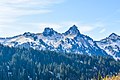 A snowy Tatoosh Range rises above the treeline. (bd00c08e-cdcf-4e34-a9b3-90796d8af6ce).JPEG 6,000 × 4,000; 6.91 MB
-

-
 Cascade Mountains and Paradise Valley, 1888 (WARNER 581).jpeg 768 × 459; 58 KB
-
 Cliff Lake Tatoosh Range MRNP - panoramio.jpg 1,536 × 2,048; 650 KB
-
-
 Cooperation with Permittees - All States - DPLA - 69f0d7928f2692b10b10d8cf3d9db753.jpg 4,797 × 3,876; 2.24 MB
-
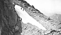
 Cowlitz Glacier on Mt. Rainier, 1905 - DPLA - aec070e830f354e3b8285120b94c6f3f.jpg 3,401 × 2,044; 886 KB
-
 Dead trees and Tatoosh mountains. (d950d6ca5e474a42a75c2b6dbad2e83e).JPG 3,072 × 2,304; 1.99 MB
-
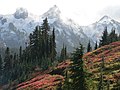
 Fall color with Tatoosh background. Alta Vista Trail. (79b9d1d9a16b44a288578097753f4901).JPG 2,560 × 1,920; 2.35 MB
-
 Fall colors with snow and clouds on Tatoosh range (d64cbacb4bc24709b638c2d257795b93).JPG 2,560 × 1,920; 2.35 MB
-

-

-
 Lower parking lot. Clouds over Tatoosh. (83f981e58129455f84d6d9f1035b7dc9).JPG 4,139 × 2,035; 2.22 MB
-
 Lower parking lot. Clouds over Tatoosh. (da08aefdd5734d2292ca9b60507fe710).JPG 4,288 × 2,848; 3.18 MB
-
 Meadow, trees and Tatoosh Range (94fbf47fc67741729892bbcef5ad60a8).JPG 2,560 × 1,920; 2.25 MB
-

-
 Over Tatoosh Range (8ec3582aa2e7483fb1bd8aa1f1961896).JPG 3,072 × 2,304; 2 MB
-

-
-

-
 Pinnacle Peak Tatoosh Range.jpg 2,123 × 1,425; 884 KB
-

-

-
 Tatoosh Peaks sign.jpg 2,653 × 765; 257 KB
-
 Tatoosh Range (052fcd39bda24eb8adee03226267da04).JPG 2,560 × 1,920; 2.18 MB
-
 Tatoosh Range (09ba68f575b44078bc02651b061714b9).JPG 2,560 × 1,920; 2.33 MB
-
 Tatoosh Range (09fa6e48a95a4597a369e229079559b4).JPG 2,560 × 1,920; 2.31 MB
-
 Tatoosh Range (16bfd229f0e041c2819c9d8f1734deca).jpg 2,140 × 1,457; 671 KB
-
 Tatoosh Range (2995a9b20eac44e78394b2d3eaa16606).JPG 2,816 × 2,112; 2.61 MB
-
 Tatoosh Range (335ce5ba39ec4ec8947eeda65c8c429c).JPG 2,560 × 1,920; 1.93 MB
-
 Tatoosh Range (7f2c0049e94e4d8b962affca66f875a3).JPG 4,288 × 2,848; 3.02 MB
-
 Tatoosh Range (84b727764f064935b613b5e4a31f5c90).JPG 4,288 × 2,848; 3.01 MB
-
 Tatoosh Range (b01a17ec1f0d44eab560b44de3b1fc24).JPG 1,838 × 1,221; 946 KB
-
 Tatoosh Range (beb28633dc8f43f3b50bfd6fd1109f3b).JPG 2,560 × 1,920; 1.76 MB
-
 Tatoosh Range (bf281028e99b4270a669b302b7f91628).JPG 2,560 × 1,920; 2.24 MB
-
 Tatoosh Range (e074801ec285425c8252adb18f3ed1a7).JPG 3,072 × 2,304; 1.99 MB
-
 Tatoosh Range - Names.jpg 4,288 × 3,216; 4.5 MB
-
 Tatoosh Range and alpine meadow - Flickr - brewbooks (1).jpg 4,468 × 3,288; 3.57 MB
-
 Tatoosh Range and alpine meadow - Flickr - brewbooks.jpg 4,608 × 3,456; 3.88 MB
-
 Tatoosh Range at Mt. Rainier, 1905 - DPLA - 7d0832dfc18066eceeb64b88a9793a19.jpg 5,388 × 3,745; 2.7 MB
-
 Tatoosh Range Diagram.jpg 4,288 × 3,216; 4.88 MB
-

-
 Tatoosh Range in autumn (9ee99288e0af45cc8fda3fbb1ef0bc55).JPG 2,560 × 1,920; 2.18 MB
-

-
 Tatoosh Range through silhouetted trees. (a5620b76283b4e62a78502f1a9301ac1).JPG 2,560 × 1,920; 2.01 MB
-
 Tatoosh Range view - Flickr - brewbooks.jpg 4,608 × 3,456; 3.85 MB
-
 Tatoosh Range, Washington, 1920 (WASTATE 2946).jpeg 768 × 592; 48 KB
-
 Tatoosh Range. Late meltout--note date. (7106b20febb04adb993c73f327de63aa).JPG 2,816 × 2,112; 2.21 MB
-
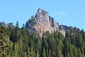
 The Castle in Tatoosh Range.jpg 802 × 680; 410 KB
-

-

-
-
 Two ravens sitting on dead tree. Tatoosh Range. (83c09cffdd3c40919fa2229f0c8c1d02).JPG 2,883 × 2,163; 2.01 MB
-
 Unicorn and Foss.jpg 3,872 × 2,592; 6.37 MB
-
 Unicorn Peak in the Tatoosh Range of Mount Rainier National Park.jpg 1,797 × 1,215; 691 KB
-

-

-
 View of Tatoosh Range with False hellebore (ba7191f00ace4809b1672ab2cf8e3442).JPG 2,560 × 1,920; 2.21 MB
-
 Wahpenayo Peak in the Tatoosh Range (d0e53cf19f224fa39f7a5098a8837d8f).JPG 2,560 × 1,920; 2.19 MB
-
 Western Tatoosh Range (3b0edcfb81ee49958c171adcd0256d2d).JPG 3,072 × 2,304; 1.92 MB
-

.JPEG)
.JPEG)
.JPEG)
.jpeg)

.jpeg)


.JPG)
.JPG)
.JPG)
-_Unicorn,_Foss,_Castle,_Pinnacle_(92fdcdbc90144ae586e3fd662bb14c20).JPG)
-_Castle,_Pinnacle,_Plummer,_Denman,_Lane,_Wahpenaho._(55ca88ca7e9644fa9d634cb530534b5e).JPG)
.JPG)
.JPG)
.JPG)
._Not_in_MRNP._(76b96d8dda1a435eb005e2618ee3a726).JPG)
.JPG)
.jpg)
.jpeg)

.JPG)

.JPG)
.JPG)
.JPG)
.jpg)
.JPG)
.JPG)
.JPG)
.JPG)
.JPG)
.JPG)
.JPG)
.JPG)

.jpg)


.jpeg)
.JPG)
-_Lane,_Wahpenayo,_Chutla_(cbfbf4bb65774ea0bcd766a85f09711c).JPG)
.JPG)

.jpeg)
.JPG)

.jpg)
.JPG)
.jpeg)
.JPG)


,_snow,_Tatoosh_Ranger_and_Mt_Adams._(dd12842ecb834adaa6be8ba3f8a14998).JPG)
._(43f992e821884f8d9b0697e30ddcef12).JPG)
.JPG)
.JPG)
.JPG)
.jpeg)
.jpeg)