Category:Tauherenikau River Bridge
| Object location | | View all coordinates using: OpenStreetMap |
|---|
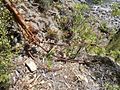
At the left bank of the Tauherenikau River remind remnants on two former bridges; at the right bank everything has been swept away by the river.
Some pictures show the anchors of a swingbridge, with turnbuckles, shackles and rusty wires mounted with clamps and cringles.
More downstream the bush hides the square concrete foundation where the pylon of another suspension bridge had been erected.
Media in category "Tauherenikau River Bridge"
The following 7 files are in this category, out of 7 total.
-
 Tauherenikau River Bidge 0.jpg 2,048 × 1,536; 697 KB
-
 Tauherenikau River Bidge 1.jpg 2,048 × 1,536; 687 KB
-
 Tauherenikau River Bidge 2.jpg 2,048 × 1,536; 695 KB
-
 Tauherenikau River Bidge 4.jpg 2,048 × 1,536; 678 KB
-
 Tauherenikau River Bidge 5.jpg 2,048 × 1,536; 685 KB
-
 Tauherenikau River Bidge 6.jpg 2,048 × 1,536; 676 KB
-
 Tauherenikau River Bidge foundation.jpg 2,048 × 1,536; 694 KB


