Category:Taupo Volcanic Zone
日本語: タウポ火山帯
· volcanic zone in New Zealand .jpg) | |||||
| Upload media | |||||
| Instance of | |||||
|---|---|---|---|---|---|
| Location |
| ||||
| Different from | |||||
 | |||||
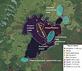
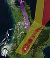
Taupo Volcanic Zone is the highly active volcanic area in the North Island of New Zealand, that stretches from Mount Ruapehu to White Island.
Subcategories
This category has the following 44 subcategories, out of 44 total.
*
+
G
H
L
- Lake Okareka (11 F)
- Lake Okataina (2 F)
- Lake Rotoaira (15 F)
M
- Mangakino Caldera (3 F)
- Mount Tauhara (9 F)
- Moutohora Island (19 F)
N
O
R
T
- Tikitere (34 F)
W
- Wahianoa River (5 F)
Ō
Media in category "Taupo Volcanic Zone"
The following 30 files are in this category, out of 30 total.
-
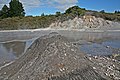
 00 1055 Taupo Volcanic Zone - Tikitere (Hell's Gate).jpg 3,150 × 2,100; 8.51 MB
-
 00 1060 Tikitere (Taupo Volcanic Zone).jpg 3,150 × 2,100; 6.86 MB
-
 00 1062 Tikitere geothermal area (Hell´s Gate) - Taupo Volcanic Zone.jpg 3,168 × 2,112; 7.08 MB
-
 BayofPlentyA2002296.jpg 616 × 864; 493 KB
-
 CentralPlateauNZ.jpg 9,926 × 1,025; 4.57 MB
-
 City of Rotorua.jpg 2,340 × 1,623; 405 KB
-
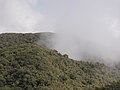 Clouds backed up against Mount Tauhara.jpg 1,024 × 768; 253 KB
-
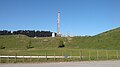
 Geothermal drills near Taupo I.jpg 1,600 × 1,200; 1.1 MB
-
 Geothermal drills near Taupo II.jpg 1,800 × 1,000; 947 KB
-
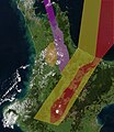 HB.Rift.Zones.North.Island.NZ.jpg 1,302 × 1,506; 531 KB
-
 Lady Knox Geyser.JPG 2,472 × 3,296; 999 KB
-
 Lake Rotokawau.jpg 1,950 × 1,268; 641 KB
-
 Lake taupo landsat volcanic features vents.jpg 1,102 × 948; 277 KB
-
 Mount Tauhara from Lake Taupo.jpg 1,024 × 768; 280 KB
-
 New Zealand - A road in the late hour. - 9759.jpg 4,368 × 2,912; 3.46 MB
-
 New Zealand - Landscape - 8668.jpg 4,368 × 2,826; 4.87 MB
-
 New Zealand - Landscape - 8674.jpg 4,368 × 2,912; 5.41 MB
-
 New Zealand - Landscape - 8675.jpg 4,368 × 2,596; 4.92 MB
-

-

-
 Oruanui Loc1287 u3 25-33cm.jpg 3,872 × 2,592; 805 KB
-
 Rift.Zones.North.Island.NZ.jpg 1,302 × 1,506; 530 KB
-
 Taupo.Volcanic.Zone.North.Island.NZ.JPG 616 × 864; 104 KB
-
 View over Taupo and Lake Taupo from Mount Tauhara.jpg 1,024 × 768; 322 KB
-
 Wairakei terraces 2.jpg 3,264 × 2,448; 2.85 MB
-
 Wairakei terraces 3.jpg 3,264 × 2,448; 2.61 MB
-
 Wairakei Terraces.jpg 3,264 × 2,448; 3.32 MB
-
 Wairakei terraces.jpg 3,264 × 2,448; 2.94 MB
-
 Whakamaru.Eruption.jpg 1,100 × 1,450; 472 KB
-
 Whakatane2West.jpg 2,816 × 2,112; 1.95 MB
.jpg)
_-_Taupo_Volcanic_Zone.jpg)


_(cropped).jpg)
.jpg)


