Category:Texas State Highway 23
 | number: | (twenty-three) |
|---|---|---|
| State highways in Texas: | 3 · 4 · 6 · 7 · 10 · 11 · 14 · 15 · 16 · 17 · 18 · 19 · 21 · 22 · 23 · 24 · 27 · 31 · 34 · 35 · 36 · 37 |
state highway in Lipscomb County, Texas, United States  | |||||
| Upload media | |||||
| Instance of | |||||
|---|---|---|---|---|---|
| Location | Lipscomb County, Texas | ||||
| Transport network | |||||
| Connects with | |||||
| Owned by |
| ||||
| Maintained by |
| ||||
| Inception |
| ||||
| Length |
| ||||
| Terminus |
| ||||
 | |||||
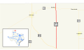
English: Media related to Texas State Highway 23, a 28.704-mile (46.195 km) state highway in Lipscomb County, Texas, United States, that connects U.S. Route 83 (northwest of Canadian) with Oklahoma State Highway 23 in Oklahoma.
Subcategories
This category has only the following subcategory.
Media in category "Texas State Highway 23"
The following 3 files are in this category, out of 3 total.
-
 State Highway 23 Bridge at the Clear Fork of the Brazos River.jpg 2,408 × 1,354; 2.83 MB
-
 Texas 23 map.svg 1,088 × 645; 488 KB
-
 Texas 23.svg 384 × 384; 9 KB