Category:The Holmstead, Liverpool
| Object location | | View all coordinates using: OpenStreetMap |
|---|
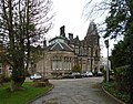
c. 1840s house on North Mossley Hill Road, later a convent and now apartments. Grade II listed.
building in Liverpool, Merseyside, UK  | |||||
| Upload media | |||||
| Instance of | |||||
|---|---|---|---|---|---|
| Location | Liverpool, Merseyside, North West England, England | ||||
| Heritage designation |
| ||||
 | |||||
Media in category "The Holmstead, Liverpool"
The following 3 files are in this category, out of 3 total.
-
 Holmstead Cottage and entrance.jpg 5,152 × 3,864; 6.7 MB
-
 The Holmstead, Liverpool-1.jpg 4,599 × 3,591; 8.48 MB
-
 The Holmstead, Liverpool-2.jpg 4,615 × 3,553; 8.26 MB

