Category:The Trustees of Reservations
Massachusetts preservation and conservation nonprofit organization | |||||
| Upload media | |||||
| Instance of |
| ||||
|---|---|---|---|---|---|
| Location | Boston, Suffolk County, Massachusetts | ||||
| Headquarters location |
| ||||
| Legal form | |||||
| Founded by |
| ||||
| Inception |
| ||||
| Follows |
| ||||
| official website | |||||
 | |||||
Subcategories
This category has the following 51 subcategories, out of 51 total.
A
- Appleton Farms (20 F)
B
- Bartholomew's Cobble (5 F)
- Bear Swamp Reservation (3 F)
- Bear's Den (4 F)
- Bradley Estate (5 F)
C
- Colonel John Ashley House (12 F)
- Coolidge Reservation (8 F)
D
- Dexter Drumlin (3 F)
E
- Elliott Laurel (7 F)
F
- Field Farm (5 F)
- Fork Factory Brook (7 F)
- Francis William Bird Park (3 F)
- Fruitlands (53 F)
G
H
- Halibut Point State Park (28 F)
L
M
- Malcolm Preserve (2 F)
- Medfield Rhododendrons (3 F)
- Moose Hill Farm (8 F)
- Mytoi Japanese Gardens (3 F)
N
- Noanet Woodlands (12 F)
O
- The Old Manse (57 F)
P
- Pegan Hill Reservation (3 F)
R
- Rocky Narrows (4 F)
- Royalston Falls (3 F)
S
- Slocum's River Reserve (4 F)
- Stavros Reservation (3 F)
- Stevens-Coolidge Place (7 F)
T
- Tantiusques (6 F)
- Tyringham Cobble (4 F)
W
- Ward Reservation (12 F)
- Weir Hill (3 F)
- Weir River Farm (4 F)
Media in category "The Trustees of Reservations"
The following 41 files are in this category, out of 41 total.
-
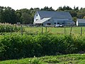
 Barns at East Over Reservation, Rochester MA.jpg 2,272 × 1,704; 1.08 MB
-
 Bay Circuit Map, by Charles William Eliot II, The Trustees of (Public) Reservations, 1930.jpg 7,500 × 10,611; 31.13 MB
-
 Brooks Woodland Preserve, Petersham MA.jpg 3,072 × 2,304; 3.73 MB
-
 ChapelBrookFalls AshfieldMA.jpg 5,616 × 3,744; 7.07 MB
-
 Charles River Link Trail, Chase Woodlands, Dover MA.jpg 3,264 × 2,448; 3.8 MB
-
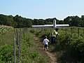
 Charles River Peninsula P1120795.jpg 2,560 × 1,920; 2.22 MB
-
 Charles River Peninsula P1120796.jpg 2,560 × 1,920; 2.32 MB
-
 Charles River Peninsula P1120805.jpg 2,560 × 1,920; 2.23 MB
-
 Charles River, Cedariver, Millis MA.jpg 3,264 × 2,448; 4.18 MB
-
 Charles River, Peters Reservation, Dover MA.jpg 3,264 × 2,448; 3.18 MB
-
 Choate House.jpg 3,072 × 2,304; 3.17 MB
-
 Conaumet Cove, Lowell Holly Reservation, Mashpee MA.jpg 3,264 × 2,448; 2.61 MB
-
 Crowninshield Island.jpg 1,500 × 1,000; 591 KB
-
 Dolbear Trail, Cormier Woods, Uxbridge MA.jpg 3,072 × 2,304; 3.04 MB
-
 DoverMA PowissetFarm.jpg 1,024 × 680; 234 KB
-
 Dry Hill, New Marlborough MA.jpg 3,072 × 2,304; 2.67 MB
-
 East Over Farms (cropped).jpg 4,272 × 611; 2.82 MB
-
 East Over Farms.jpg 4,272 × 2,848; 11.81 MB
-
 Hamlin Reservation, Ipswich MA.jpg 2,272 × 1,704; 1.27 MB
-
 Holmes Reservation, Plymouth MA.jpg 2,816 × 2,112; 1.33 MB
-
 Lunden Pond, Peaked Mountain, Monson MA.jpg 3,072 × 2,304; 2.27 MB
-
 Mashpee River, Mashpee River Reservation, Mashpee MA.jpg 3,264 × 2,448; 2.49 MB
-
 Milkweed pod P1120798.jpg 2,560 × 1,920; 1.87 MB
-
 MiseryIslandFromBeverlyFarms.jpg 1,024 × 680; 179 KB
-
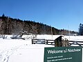 Notchview.jpg 2,560 × 1,920; 1.54 MB
-
 Powisset Farm P1120806.jpg 2,560 × 1,920; 2.41 MB
-
 Powisset Farm P1120809.jpg 2,560 × 1,920; 2.36 MB
-
 Questing, New Marlborough MA.jpg 3,072 × 2,304; 3.31 MB
-
 Quinebaug Woods, Holland MA.jpg 3,264 × 2,448; 3.71 MB
-
 Ravenswood skiers.jpg 2,048 × 1,536; 1.75 MB
-
 Rock shelter, Rock House Reservation, West Brookfield MA.jpg 3,264 × 2,448; 3.05 MB
-
 Spirit Falls, Royalston MA.jpg 3,072 × 2,304; 3.1 MB
-
 Swift River Reservation, Petersham MA.jpg 3,072 × 2,304; 2.93 MB
-
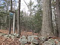
 TTOR PetticoatHillReservationTrail.jpg 1,024 × 680; 321 KB
-
 Tully Trail, Jacobs Hill, Royalston MA.jpg 3,072 × 2,304; 2.77 MB
-
 View from Hog Island.jpg 3,072 × 2,048; 1.7 MB
-
 WestBrookfieldMA LucyStoneBirthplace Foundation.jpg 1,024 × 680; 222 KB
-
 WestBrookfieldMA LucyStoneBirthplace Marker.jpg 1,024 × 680; 231 KB
-
 Westport Town Farm, Westport MA.jpg 2,272 × 1,704; 1.43 MB
-
 Whitney and Thayer Woods P1120199.jpg 2,560 × 1,920; 2.34 MB
-
 Whitney and Thayer Woods P1120204.jpg 2,560 × 1,920; 2.23 MB

_Reservations,_1930.jpg)


.jpg)