Category:The Woodlands, Clifton Park, Birkenhead
| Object location | | View all coordinates using: OpenStreetMap |
|---|
This is a category about listed building number 1201603. |
Grade II listed house in Birkenhead, Wirral, Merseyside, UK  | |||||
| Upload media | |||||
| Instance of | |||||
|---|---|---|---|---|---|
| Location | Wirral, Merseyside, North West England, England | ||||
| Heritage designation |
| ||||
 | |||||
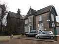
Dating to 1846, The Woodlands (10 Clifton Road and 72 Woodlands Road) are together Grade II listed.
Media in category "The Woodlands, Clifton Park, Birkenhead"
The following 4 files are in this category, out of 4 total.
-
 72 The Woodlands, Birkenhead 2018.jpg 4,593 × 3,402; 9.5 MB
-
 72 The Woodlands, Birkenhead.jpg 4,608 × 3,456; 3.37 MB
-
 The Woodlands, Birkenhead 2018-1.jpg 5,082 × 3,477; 11.79 MB
-
 The Woodlands, Birkenhead 2018-2.jpg 4,776 × 3,327; 10.14 MB


