Category:The cradle of mankind; life in eastern Kurdistan (1922)
Media in category "The cradle of mankind; life in eastern Kurdistan (1922)"
The following 21 files are in this category, out of 21 total.
-
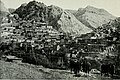 Akra from the southwest, early twentieth century.jpg 2,800 × 1,870; 1.37 MB
-
 Bridge across the Lesser Zab at Alot, early 20th century.jpg 2,992 × 2,110; 1 MB
-
 Chal. Behind the hills lies Lower Tkhuma and Salabekan valleys.jpg 2,976 × 2,082; 710 KB
-
 Church of Mar Shalitha, Qudshanis, early twentieth century.jpg 2,106 × 2,990; 991 KB
-
 The cradle of mankind; life in eastern Kurdistan (IA cradleofmankindl00wigrrich).pdf 1,012 × 1,593, 500 pages; 28.5 MB
-
 Floor plan of the Yazidi temple of Sheikh Adi, early twentieth century.jpg 2,496 × 1,654; 536 KB
-
 Lalish, early 20th century, showing the roof of the shrine of Sheikh Adi.jpg 2,126 × 2,642; 1.34 MB
-
 Lower Tkhuma.jpg 2,944 × 2,002; 1.1 MB
-

-
 Mosul viewed from the bridge, early twentieth century.jpg 2,944 × 2,074; 509 KB
-

-
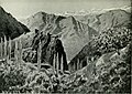
 The "picture rocks" of Bavian, early 20th century.jpg 2,114 × 2,838; 841 KB
-
 The citadel rock, Van.jpg 2,928 × 2,110; 719 KB
-
 The gate of Amadiya, early 20th century.jpg 2,106 × 2,664; 1.16 MB
-
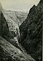
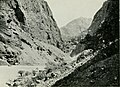 The gorge of the Zab in Tyari.jpg 2,688 × 1,960; 693 KB
-
 The Heriki valley. The mountain at the head of the valley is a shoulder of Sat Dagh.jpg 2,034 × 2,342; 993 KB
-
 The mountains of Diz and Tal, from the pass above Qudshanis.jpg 2,782 × 2,032; 1.04 MB
-
 The mountains of Tkhuma and Jilu.jpg 2,992 × 1,574; 978 KB
-
 The Qudshanis mountains from the village of Shwawutha.jpg 2,880 × 2,052; 1.26 MB
-
 The road between Tal and Julamerk in Hakkari.jpg 2,060 × 2,792; 1.16 MB
-
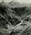
 The Zab entering the Tyari gorges.jpg 2,096 × 2,970; 688 KB


_(14576929017).jpg)


