Category:Thomas T. Tucker (ship, 1942)
| Object location | | View all coordinates using: OpenStreetMap |
|---|
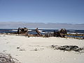
shoreline recent wreck dive site at Olifantsbospunt on the Cape Peninsula west coast  | |||||
| Upload media | |||||
| Instance of |
| ||||
|---|---|---|---|---|---|
| Location | Table Mountain National Park Marine Protected Area, Western Cape, RSA | ||||
| Yard number |
| ||||
| Country of registry | |||||
 | |||||
Ship
edit- Type: Cargo ship
- Design by:
- Order date:
- Built by: Houston SB Corp, Houston, United States
- Yard No: 30
- Keel laid:
- Launch date: 31.8.42
- Date of completion: 10.42
- Length over all: 134.6 m
- LPP: 126.8 m
- Beam: 17.3 m
- Draught: m
- GRT: 7176
- DWT: 10865
- NET:
- Main engine:
- Speed: kn
History
edit- 1942 Named: THOMAS T.TUCKER Flag: United States
- 28.11.1942 Wrecked 34.16S/18.23E
Media in category "Thomas T. Tucker (ship, 1942)"
The following 5 files are in this category, out of 5 total.
-
 Coralline and other algae at the Thomas T Tucker DSC00770.JPG 2,048 × 1,536; 1.34 MB
-
 Reef life at the Thomas T Tucker DSC00771.JPG 2,048 × 1,536; 1.36 MB
-
 Sponge at the Thomas T Tucker DSC00774.JPG 2,048 × 1,536; 1.35 MB
-
 Thomas T Tucker banner 1.jpg 2,100 × 300; 729 KB
-
 Thomas Tucker shipwreck 24 Jun 2006.JPG 2,592 × 1,944; 2.24 MB


