Category:Thruxton, Hampshire
village and civil parish in Test Valley, Hampshire, England  | |||||
| Upload media | |||||
| Instance of | |||||
|---|---|---|---|---|---|
| Location | Test Valley, Hampshire, South East England, England | ||||
 | |||||
English: Thruxton is just off the A303 road five miles (8 km) west of Andover. It is a village with a Manor House, thatched cottages and village green. Pillhill Brook runs from Thruxton Down through the grounds of the Manor House and along the village street to Mullen's Pond, a natural habitat for many species of migratory birds and wild plants.
Subcategories
This category has the following 6 subcategories, out of 6 total.
G
- George Inn, Thruxton (4 F)
T
- Thruxton Airfield (26 F)
- Thruxton Memorial Hall (17 F)
W
- White Horse, Thruxton (6 F)
Media in category "Thruxton, Hampshire"
The following 83 files are in this category, out of 83 total.
-
 A303 bridge over minor road west of Thruxton - geograph.org.uk - 6223244.jpg 1,600 × 1,145; 653 KB
-
 A303 eastbound - geograph.org.uk - 5629378.jpg 640 × 428; 77 KB
-
 A303 eastbound - geograph.org.uk - 5629382.jpg 640 × 428; 82 KB
-
 A303 eastbound - geograph.org.uk - 5629386.jpg 640 × 428; 90 KB
-
 A303 exit for Stanbury Road - geograph.org.uk - 4045004.jpg 3,648 × 2,736; 1.9 MB
-
 A303 in a deep cutting - geograph.org.uk - 5277381.jpg 640 × 439; 59 KB
-
 A303 junction for East Cholderton and Thruxton Village - geograph.org.uk - 3703385.jpg 1,585 × 1,034; 865 KB
-
 A303 north of Thruxton Farm - geograph.org.uk - 3824653.jpg 3,648 × 2,736; 1.31 MB
-
 A303 towards Thruxton - geograph.org.uk - 3702318.jpg 1,227 × 786; 499 KB
-
 A303 westbound - geograph.org.uk - 4575701.jpg 640 × 480; 49 KB
-
 A303 westbound - geograph.org.uk - 4575706.jpg 640 × 456; 49 KB
-
 A303 westbound - geograph.org.uk - 5723576.jpg 640 × 428; 86 KB
-
 A303, eastbound - geograph.org.uk - 4784704.jpg 640 × 426; 43 KB
-
 A303, westbound - geograph.org.uk - 5277380.jpg 640 × 406; 39 KB
-
 A303, westbound - geograph.org.uk - 5277460.jpg 640 × 426; 68 KB
-
 A338 nears Parkhouse Roundabout - geograph.org.uk - 4234074.jpg 640 × 482; 60 KB
-
 Advance sign, westbound, for A303 junction with A338 - geograph.org.uk - 6223248.jpg 1,600 × 1,044; 533 KB
-
 Alexander's Belt Fields - geograph.org.uk - 6054057.jpg 4,272 × 2,848; 5.77 MB
-
 Alexander's Belt Fields - geograph.org.uk - 6054061.jpg 4,272 × 2,848; 6.93 MB
-
 Bullocks in meadow at Fyfield - geograph.org.uk - 6142872.jpg 1,024 × 683; 229 KB
-
 Car-park, Thruxton - geograph.org.uk - 813630.jpg 640 × 480; 134 KB
-
 Chimneys, Home Farm - geograph.org.uk - 2834156.jpg 480 × 640; 70 KB
-
 Cholderton, Park House Motel - geograph.org.uk - 2072201.jpg 1,024 × 768; 171 KB
-
 Cockerel, Home Farm - geograph.org.uk - 2834066.jpg 640 × 481; 91 KB
-
 Cockerel, Home Farm - geograph.org.uk - 2834072.jpg 640 × 480; 118 KB
-
 Entrance, Thruxton Airport and Race Circuit - geograph.org.uk - 5910749.jpg 1,024 × 684; 177 KB
-
 Field and house beside Thruxton Church - geograph.org.uk - 6142849.jpg 1,024 × 683; 293 KB
-
 Field footpath going south to the A303 - geograph.org.uk - 3336233.jpg 600 × 800; 176 KB
-

-

-
 Lay-by, A303 - geograph.org.uk - 4577541.jpg 640 × 480; 60 KB
-
 Layby on the A303 near Shipton Bellinger - geograph.org.uk - 5767240.jpg 2,304 × 1,728; 878 KB
-
 Old Forge, Thruxton - geograph.org.uk - 5050773.jpg 4,896 × 3,672; 5.08 MB
-
 Road towards Thruxton - geograph.org.uk - 4675203.jpg 640 × 427; 109 KB
-
 Road, Thruxton - geograph.org.uk - 812742.jpg 640 × 480; 131 KB
-
 Shepherd's Hut, Home Farm - geograph.org.uk - 2834055.jpg 640 × 480; 82 KB
-
 Stanbury Road, Thruxton - geograph.org.uk - 5389323.jpg 1,024 × 804; 213 KB
-
 Stanbury Road, Thruxton, view east - geograph.org.uk - 5389375.jpg 1,024 × 788; 176 KB
-

-
 Test Valley , The A303 - geograph.org.uk - 5739427.jpg 6,000 × 4,000; 5.3 MB
-
 Test Valley , The A303 - geograph.org.uk - 5739429.jpg 6,000 × 4,000; 6 MB
-
 Test Valley , The A303 - geograph.org.uk - 5739430.jpg 6,000 × 4,000; 5.86 MB
-
 Test Valley , The A303 - geograph.org.uk - 5739431.jpg 6,000 × 4,000; 5.29 MB
-
 Thatched cottages in Thruxton, Hampshire - geograph 4045024.jpg 3,648 × 2,736; 1.96 MB
-
 The A303 near Shipton Bellinger - geograph.org.uk - 5767248.jpg 2,304 × 1,728; 818 KB
-
 The Library, Thruxton - geograph.org.uk - 5050786.jpg 3,672 × 4,896; 5.05 MB
-
 Thruxton - Bulldozers - geograph.org.uk - 1161135.jpg 640 × 480; 97 KB
-
 Thruxton - Cottage - geograph.org.uk - 1122272.jpg 640 × 480; 66 KB
-
 Thruxton - Crusher - geograph.org.uk - 1161186.jpg 640 × 480; 85 KB
-
 Thruxton - Crusher - geograph.org.uk - 1161200.jpg 640 × 480; 89 KB
-
 Thruxton - Diggers - geograph.org.uk - 1161147.jpg 640 × 480; 88 KB
-
 Thruxton - Entrance To Circuit - geograph.org.uk - 1127816.jpg 640 × 480; 88 KB
-

-

-

-
 Thruxton - Fields - geograph.org.uk - 1127828.jpg 640 × 480; 62 KB
-
 Thruxton - Frosty Field - geograph.org.uk - 1122279.jpg 640 × 480; 92 KB
-

-

-
 Thruxton - Milestone - geograph.org.uk - 1127770.jpg 480 × 640; 145 KB
-
 Thruxton - Mount Hardcore - geograph.org.uk - 1161217.jpg 640 × 480; 104 KB
-
 Thruxton - Mullens Pond - geograph.org.uk - 1128051.jpg 640 × 480; 102 KB
-
 Thruxton - Mullens Pond - geograph.org.uk - 1128061.jpg 640 × 480; 67 KB
-
 Thruxton - Phone Box On The Green - geograph.org.uk - 1126418.jpg 640 × 480; 93 KB
-
 Thruxton - Pillhill Brook - geograph.org.uk - 1122240.jpg 480 × 640; 141 KB
-
 Thruxton - Pillhill Brook - geograph.org.uk - 1122245.jpg 640 × 480; 145 KB
-
 Thruxton - Pillhill Brook - geograph.org.uk - 1122256.jpg 640 × 480; 98 KB
-
 Thruxton - Pillhill Brook - geograph.org.uk - 1128033.jpg 480 × 640; 119 KB
-
 Thruxton - The Pillhill Brook - geograph.org.uk - 1128009.jpg 480 × 640; 91 KB
-
 Thruxton - Thruxton Industrial Estate - geograph.org.uk - 1161062.jpg 640 × 480; 107 KB
-
 Thruxton - Triplet Cottages - geograph.org.uk - 1127854.jpg 640 × 480; 79 KB
-
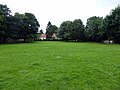
 Thruxton - Village Green - geograph.org.uk - 1126440.jpg 640 × 480; 122 KB
-
 Thruxton - Wiremead Lane - geograph.org.uk - 1128000.jpg 480 × 640; 78 KB
-
 Thruxton church - geograph.org.uk - 4392671.jpg 640 × 480; 218 KB
-
 Thruxton Down - Houses - geograph.org.uk - 1718060.jpg 1,024 × 768; 133 KB
-
 Thruxton Down - Houses - geograph.org.uk - 1718065.jpg 1,024 × 768; 217 KB
-
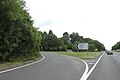
 Thruxton turning, A303 - geograph.org.uk - 5277373.jpg 640 × 372; 51 KB
-
 Thruxton Village turn off, A303 - geograph.org.uk - 4784705.jpg 640 × 398; 43 KB
-
 Thruxton, ancient milepost - geograph.org.uk - 3371477.jpg 640 × 480; 109 KB
-
 Turn off to Thruxton - geograph.org.uk - 5277372.jpg 640 × 426; 75 KB
-
 Village Green, Thruxton - geograph.org.uk - 5050779.jpg 4,896 × 3,672; 5.91 MB
-
 Westbound off slip road from A303 for Thruxton village - geograph.org.uk - 6223236.jpg 1,600 × 1,065; 543 KB
-


