Category:Tockenham
village and civil parish in Wiltshire, England  | |||||
| Upload media | |||||
| Instance of | |||||
|---|---|---|---|---|---|
| Location | Wiltshire, South West England, England | ||||
| official website | |||||
 | |||||
Tockenham is a village and civil parish in Wiltshire, England. Its nearest town is Royal Wootton Bassett, about 3 miles (4.8 km) away to the north east.
Subcategories
This category has the following 3 subcategories, out of 3 total.
T
- St Giles' church, Tockenham (2 F)
- Tockenham War Memorial (1 F)
- Tockenham Wick (7 F)
Media in category "Tockenham"
The following 52 files are in this category, out of 52 total.
-
 2011 , A3102 heading east toward Wootton Bassett - geograph.org.uk - 2687177.jpg 3,969 × 2,949; 5.56 MB
-
 2011 , A3102 heading north east near the end of Bowd's Lane - geograph.org.uk - 2679219.jpg 3,809 × 2,591; 4.04 MB
-
 2011 , A3102 heading south west to Lyneham - geograph.org.uk - 2687190.jpg 3,604 × 2,644; 3.94 MB
-
 2011 , East from the A3102 - geograph.org.uk - 2687194.jpg 3,518 × 2,041; 3.15 MB
-
 2011 , Ploughed field bordering the A3102 - geograph.org.uk - 2679237.jpg 4,752 × 3,168; 6.79 MB
-
 2011 , The lane to Tockenham - geograph.org.uk - 2653216.jpg 3,603 × 2,770; 4.62 MB
-
 2011 , Trow Lane seen from the A3102 - geograph.org.uk - 2687197.jpg 3,792 × 2,615; 4.09 MB
-
 A3102 junction with Trow Lane - geograph.org.uk - 2948942.jpg 3,556 × 2,672; 2.19 MB
-
 A3102 towards Wootton Bassett - geograph.org.uk - 5669000.jpg 640 × 428; 154 KB
-
 A3102 towards Wootton Bassett - geograph.org.uk - 5669006.jpg 640 × 428; 118 KB
-
 A3102 towards Wootton Bassett - geograph.org.uk - 5669011.jpg 640 × 428; 94 KB
-
 Bus shelter at Tockenham Corner - geograph.org.uk - 3209447.jpg 1,024 × 758; 578 KB
-
 Cattle near Tockenham Wick - geograph.org.uk - 2054656.jpg 640 × 481; 86 KB
-
 Chessley Hill Farm - geograph.org.uk - 3239098.jpg 640 × 322; 39 KB
-
 Chessley Hill Farm - geograph.org.uk - 5339734.jpg 640 × 426; 53 KB
-
 Exit from Teagles Copse - geograph.org.uk - 4735819.jpg 3,264 × 2,448; 1.94 MB
-
 Farmland east of Tockenham - geograph.org.uk - 1187567.jpg 640 × 480; 152 KB
-

-
 Footpath near Tockenham Wick - geograph.org.uk - 2054642.jpg 640 × 480; 77 KB
-
 Footpath near Tockenham Wick - geograph.org.uk - 2054648.jpg 640 × 480; 65 KB
-
 Greenway farm - geograph.org.uk - 307248.jpg 640 × 480; 91 KB
-
 Greenway Farm, Tockenham West - geograph.org.uk - 4775872.jpg 3,264 × 2,448; 1.96 MB
-
 Greenway, near Tockenham - geograph.org.uk - 1187603.jpg 640 × 480; 142 KB
-
 Greenway, Tockenham - geograph.org.uk - 4728025.jpg 3,264 × 2,448; 1.95 MB
-
 Houses in Tockenham - geograph.org.uk - 840219.jpg 640 × 479; 107 KB
-
 Meadow Court, Tockenham - geograph.org.uk - 3497280.jpg 640 × 394; 195 KB
-
 Milestone and the A3012, near Tockenham - geograph.org.uk - 1209247.jpg 640 × 480; 202 KB
-
 Milestone on the A3102, Tockenham - geograph.org.uk - 1209244.jpg 640 × 480; 186 KB
-
 Near Thickthorn Farm, east of Preston - geograph.org.uk - 1187657.jpg 640 × 480; 183 KB
-
 Pasture between Tockenham and Bushton - geograph.org.uk - 1187637.jpg 640 × 479; 194 KB
-
 Pasture land - geograph.org.uk - 6000349.jpg 1,024 × 681; 138 KB
-
 Pasture, Hart Farm - geograph.org.uk - 5013123.jpg 640 × 426; 51 KB
-
 Ploughed field, Trow Lane, Tockenham - geograph.org.uk - 1209061.jpg 640 × 480; 240 KB
-
 Public footpath, Teagles Copse, near Tockenham Corner - geograph.org.uk - 4735818.jpg 3,264 × 2,448; 1.96 MB
-
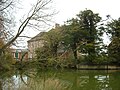 Queen Court Farm and moat - geograph.org.uk - 4728022.jpg 3,264 × 2,448; 1.94 MB
-
 Road drain, A3102 near Tockenham - geograph.org.uk - 1209212.jpg 640 × 480; 162 KB
-

-
 Sign, Middle Hill Farm, near Tockenham - geograph.org.uk - 1187593.jpg 640 × 480; 103 KB
-
 Steps, Teagles Copse, near Tockenham Corner - geograph.org.uk - 4735811.jpg 2,448 × 3,264; 4.42 MB
-
 Stream, Teagles Copse, near Tockenham Corner - geograph.org.uk - 4735817.jpg 3,264 × 2,448; 1.92 MB
-
 Teagles Copse, near Tockenham Corner - geograph.org.uk - 4735815.jpg 3,264 × 2,448; 1.89 MB
-

-

-
 The road north out of Tockenham - geograph.org.uk - 840224.jpg 640 × 395; 89 KB
-
 The road to Tockenham - geograph.org.uk - 1187573.jpg 640 × 480; 190 KB
-

-
 Tockenham Corner - geograph.org.uk - 4728051.jpg 3,264 × 2,448; 1.93 MB
-
 Tockenham Court Farm - geograph.org.uk - 4728033.jpg 3,264 × 2,448; 1.95 MB
-
 Tockenham rail bridge - geograph.org.uk - 4735853.jpg 3,186 × 2,364; 4.5 MB
-
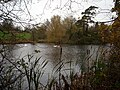 Tockenham Reservoir, Wilts & Berks Canal - geograph.org.uk - 4735845.jpg 3,264 × 2,448; 1.93 MB
-
 Trow Lane, near Tockenham - geograph.org.uk - 1209032.jpg 640 × 480; 212 KB
-
 Trow Lane,Tockenham - geograph.org.uk - 1209071.jpg 479 × 640; 167 KB


_Bridge_over_disused_Wilts_%26_Berks_Canal_-_geograph.org.uk_-_4735848.jpg)


