Category:Tockholes
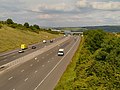
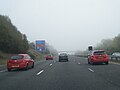
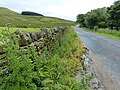
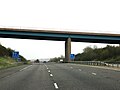
English: Tockholes is a village and civil parish which forms part of the Blackburn with Darwen unitary authority in the North west of England. Tockholes consists of the village of Tockholes itself and the Hamlet of Ryal Fold, and has a population of 454. It lies on the West Pennine Moors and is surrounded by the towns of Blackburn to the North and Darwen to the East and by the villages of Belmont to the south and Withnell to the West. Darwen Tower is a prominent local landmark that lies to the east of Tockholes and The Roddlesworth Reservoirs and Tockholes forest plantation lie to the south with the M65 passing to the north and the A675 to the south. (→Tockholes)
Nederlands: Tockholes is een plaats en civil parish in het bestuurlijke gebied Blackburn with Darwen, in het Engelse graafschap Lancashire met 454 inwoners. (→Tockholes)
Polski: Tockholes – wieś w Anglii, w hrabstwie ceremonialnym Lancashire, w dystrykcie (unitary authority) Blackburn with Darwen. Leży 33 km na północny zachód od miasta Manchester i 293 km na północny zachód od Londynu. W 2001 miejscowość liczyła 454 mieszkańców. (→Tockholes)
village in the United Kingdom  | |||||
| Upload media | |||||
| Instance of | |||||
|---|---|---|---|---|---|
| Location | Blackburn with Darwen, Lancashire, North West England, England | ||||
 | |||||
Subcategories
This category has the following 5 subcategories, out of 5 total.
Media in category "Tockholes"
The following 200 files are in this category, out of 236 total.
(previous page) (next page)-
 A distant view of Darwen Tower - geograph.org.uk - 5647030.jpg 4,799 × 3,355; 2.11 MB
-
 A view of the valley at Tockholes - geograph.org.uk - 5690824.jpg 1,280 × 960; 963 KB
-
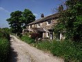
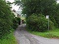
 Access lane to several farms - geograph.org.uk - 2354797.jpg 3,872 × 2,592; 5.84 MB
-
 Approaching Hollinshead Hall - geograph.org.uk - 3156949.jpg 800 × 600; 250 KB
-
 Bell on Darwen Golf Course - geograph.org.uk - 5646089.jpg 3,687 × 4,806; 2.39 MB
-
 Bethesda Chapel Cemetery, Tockholes - geograph.org.uk - 3496670.jpg 1,024 × 768; 749 KB
-
 Bluebell woods near Higher Whitehalgh Farm - geograph.org.uk - 2376076.jpg 3,872 × 2,592; 6.39 MB
-
 Bottom of Morris Brow - geograph.org.uk - 3036368.jpg 800 × 600; 739 KB
-
 Bridge at Bradley - geograph.org.uk - 5140443.jpg 640 × 480; 115 KB
-
 Bridge over the M65 - geograph.org.uk - 2354905.jpg 3,872 × 2,592; 4.13 MB
-

-
 Bus stop on Tockholes Road - geograph.org.uk - 3477761.jpg 4,000 × 2,666; 5.89 MB
-
 Car Park by the church, Churchtown - geograph.org.uk - 1277833.jpg 640 × 480; 84 KB
-
 Cartridge Hill - geograph.org.uk - 2065335.jpg 3,872 × 2,592; 3.64 MB
-
 Cartridge Hill - geograph.org.uk - 3323954.jpg 2,592 × 1,944; 1.84 MB
-
 Chapels Lane and Chapels Farm Barn - geograph.org.uk - 3036468.jpg 800 × 600; 780 KB
-
 Chapels Lane, Tockholes - geograph.org.uk - 2972772.jpg 640 × 426; 96 KB
-
 Chapels Lane, Tockholes - geograph.org.uk - 2972816.jpg 4,592 × 3,056; 6.66 MB
-
 Chapels Lane, Tockholes - geograph.org.uk - 3036458.jpg 800 × 600; 834 KB
-
 Chapels Lane, Tockholes - geograph.org.uk - 3036591.jpg 800 × 600; 874 KB
-
 Chapels Lane, Tockholes - geograph.org.uk - 990715.jpg 640 × 480; 146 KB
-
 Chapels Lane, Tockholes - geograph.org.uk - 990728.jpg 640 × 480; 150 KB
-
 Conyries Plantation - geograph.org.uk - 2659236.jpg 3,988 × 2,372; 4.24 MB
-
 Crookfield Road (2) - geograph.org.uk - 879771.jpg 472 × 640; 108 KB
-
 Dan Dare prepares for lift off - geograph.org.uk - 4691103.jpg 4,000 × 3,000; 3.37 MB
-
 Dappled shade in Sunnyhurst Wood - geograph.org.uk - 3562022.jpg 1,024 × 768; 760 KB
-
 Darwen Moor, Tockholes Road - geograph.org.uk - 3036689.jpg 800 × 600; 753 KB
-
 Darwen Moor, Witton Weavers Way - geograph.org.uk - 3036682.jpg 800 × 601; 775 KB
-
 Dean Lane - geograph.org.uk - 6271888.jpg 850 × 1,280; 852 KB
-
 Derelict barn in farmland near Tockholes - geograph.org.uk - 3562024.jpg 1,024 × 754; 399 KB
-
 Derelict barn on Green Hill - geograph.org.uk - 4691096.jpg 1,024 × 768; 647 KB
-
 Earnsdale Reservoir - geograph.org.uk - 6271886.jpg 1,280 × 850; 580 KB
-
 Earnsdale Reservoir dam - geograph.org.uk - 6271891.jpg 1,280 × 850; 385 KB
-
 Earnsdale Reservoir dam - geograph.org.uk - 6271894.jpg 1,280 × 720; 453 KB
-
 Earnsdale Reservoir near Darwen - geograph.org.uk - 5699499.jpg 800 × 485; 82 KB
-
 Earnsdale Reservoir with view to The Jubilee Tower - geograph.org.uk - 5646203.jpg 3,713 × 4,991; 4.03 MB
-
 Farmland at Tockholes - geograph.org.uk - 3562012.jpg 1,024 × 768; 530 KB
-
 Farmland at Tockholes - geograph.org.uk - 4691375.jpg 1,024 × 768; 848 KB
-
 Fields southeast of Hollinshead Terrace - geograph.org.uk - 3155581.jpg 800 × 600; 126 KB
-
 Footpath at Higher Crow Trees Farm - geograph.org.uk - 3496661.jpg 1,024 × 768; 665 KB
-
 Footpath sign, Stepback Brook - geograph.org.uk - 6273655.jpg 850 × 1,280; 360 KB
-
 Footpath to Hollinshead Hall - geograph.org.uk - 2659214.jpg 4,000 × 2,415; 5.95 MB
-
 Footpath to Tockholes - geograph.org.uk - 2376036.jpg 3,872 × 2,592; 3.32 MB
-
 Ford at Tockholes - geograph.org.uk - 4250476.jpg 3,872 × 2,592; 4.85 MB
-
 Former Post Office and Village Store - geograph.org.uk - 990732.jpg 608 × 456; 143 KB
-

-
 Gate and footpath - geograph.org.uk - 3083202.jpg 4,000 × 3,000; 5.39 MB
-
 Halliwell Fold Bridge - geograph.org.uk - 1323004.jpg 640 × 424; 226 KB
-

-
 Higher Crow Trees Farm - geograph.org.uk - 2376067.jpg 3,872 × 2,592; 5.07 MB
-
 Higher Roddlesworth Reservoir - geograph.org.uk - 5387734.jpg 1,600 × 1,200; 336 KB
-
 Higher Wenshead Farm - geograph.org.uk - 2065221.jpg 3,872 × 2,471; 3.24 MB
-
 Higher Wenshead near Darwen Hill - geograph.org.uk - 5699257.jpg 800 × 516; 98 KB
-
 Higher Whitehalgh Farm - geograph.org.uk - 5140453.jpg 640 × 480; 85 KB
-
 Higher Whitehalgh Farm.jpg 3,872 × 2,592; 4.87 MB
-
 Hollinshead Hall Well - geograph.org.uk - 5157944.jpg 3,456 × 2,592; 4.43 MB
-
 Hollinshead Hall Well House - geograph.org.uk - 5157943.jpg 3,456 × 2,592; 6.03 MB
-
 Horse at Ryal Fold - geograph.org.uk - 5699505.jpg 800 × 557; 112 KB
-
 Horse in a field - geograph.org.uk - 4691115.jpg 1,024 × 768; 916 KB
-
 Horse on a hill - geograph.org.uk - 4691111.jpg 1,024 × 768; 623 KB
-
 Horses near Kiln Bank - geograph.org.uk - 5646095.jpg 3,752 × 4,990; 3.52 MB
-

-
 Horses sheltering from the rain - geograph.org.uk - 4577260.jpg 1,024 × 768; 658 KB
-
 House at Red Lea Farm - geograph.org.uk - 2375994.jpg 3,872 × 2,592; 5.25 MB
-
 Houses at Ryal Fold - geograph.org.uk - 5699506.jpg 800 × 650; 126 KB
-
 Inside the ruins of Hollinshead Hall - geograph.org.uk - 2337808.jpg 4,491 × 2,989; 7.26 MB
-
 Ivy Cottages - geograph.org.uk - 3496664.jpg 1,024 × 768; 730 KB
-
 Junction of cloughs below Higher Whitehalgh Farm - geograph.org.uk - 2376073.jpg 3,872 × 2,592; 7.59 MB
-
 Kiln Bank Stables - geograph.org.uk - 2354782.jpg 3,872 × 2,592; 5.29 MB
-
 Lambs near Weasel Farm - geograph.org.uk - 2354804.jpg 3,872 × 2,592; 5.3 MB
-
 Large marker stone - geograph.org.uk - 450084.jpg 426 × 640; 311 KB
-
 Lion's Head, Hollinshead Well - geograph.org.uk - 5157942.jpg 3,456 × 2,592; 4.4 MB
-
 Little Arch - geograph.org.uk - 5140440.jpg 640 × 480; 136 KB
-
 Lower Hill (geograph 2464989).jpg 4,101 × 2,733; 7.62 MB
-
 Lychgate on Chapels Lane - geograph.org.uk - 3036582.jpg 800 × 600; 763 KB
-
 M65 at Meadow Head Lane Bridge - geograph.org.uk - 4507159.jpg 2,000 × 1,535; 448 KB
-
 M65 eastbound towards junction 4 - geograph.org.uk - 4507117.jpg 2,000 × 1,392; 438 KB
-
 M65 eastbound towards junction 4 - geograph.org.uk - 4507153.jpg 2,000 × 1,467; 446 KB
-
 M65 Motorway - geograph.org.uk - 3036371.jpg 800 × 601; 791 KB
-
 M65 south of Yew Tree Farm - geograph.org.uk - 4727446.jpg 640 × 481; 34 KB
-
 M65 Towards Preston - geograph.org.uk - 3036374.jpg 800 × 601; 792 KB
-
 Monument in a churchyard - geograph.org.uk - 3011864.jpg 4,000 × 3,000; 7.78 MB
-
 Moorland landscape near Tockholes - geograph.org.uk - 1730365.jpg 2,592 × 1,944; 1.28 MB
-
 Moorland towards Conyries Plantation - geograph.org.uk - 3372243.jpg 640 × 480; 65 KB
-
 New Barn Tockholes - geograph.org.uk - 753359.jpg 640 × 428; 87 KB
-
 Not a well trodden path - geograph.org.uk - 548411.jpg 640 × 426; 344 KB
-
 Not a well trodden path - geograph.org.uk - 553500.jpg 640 × 426; 365 KB
-
 Old Saxon Packhorse Trail - geograph.org.uk - 2168432.jpg 470 × 640; 206 KB
-
 Old School Lane, Tockholes - geograph.org.uk - 3011807.jpg 4,000 × 3,000; 6.31 MB
-
 Old Schoolhouse, St Stephen's Churchyard - geograph.org.uk - 3036530.jpg 800 × 600; 892 KB
-
 On Darwen Moor - geograph.org.uk - 3062085.jpg 4,000 × 3,000; 6.06 MB
-
 On Darwen Moor - geograph.org.uk - 4577241.jpg 1,024 × 768; 897 KB
-
 Path at the Stepback Plantation - geograph.org.uk - 5699239.jpg 800 × 600; 160 KB
-
 Path at Tockholes - geograph.org.uk - 1322909.jpg 424 × 640; 188 KB
-
 Path descending to Tockholes - geograph.org.uk - 2065343.jpg 3,872 × 2,592; 2.76 MB
-
 Path over Roddlesworth reservoir dam - geograph.org.uk - 5607153.jpg 5,202 × 3,465; 3.05 MB
-
 Path to open land - geograph.org.uk - 2063568.jpg 3,601 × 2,480; 3.71 MB
-
 Path to Tockholes - geograph.org.uk - 2168417.jpg 640 × 425; 175 KB
-
 Path Towards Lower Hills - geograph.org.uk - 3036601.jpg 640 × 480; 655 KB
-
 Paved path on Anglezarke Moor - geograph.org.uk - 475666.jpg 469 × 640; 340 KB
-
 Picnic tables and a view of Darwen Tower - geograph.org.uk - 3477768.jpg 4,000 × 2,666; 5.84 MB
-
 Pleasant View, Tockholes - geograph.org.uk - 3011778.jpg 1,024 × 768; 823 KB
-
 Pond in Sunnyhurst Wood - geograph.org.uk - 2353309.jpg 3,872 × 2,592; 6.8 MB
-
 Public Bridleway near Tockholes - geograph.org.uk - 3011789.jpg 4,000 × 3,000; 7.37 MB
-
 Public footpath along Tockholes Road - geograph.org.uk - 5699513.jpg 800 × 600; 102 KB
-
 Public Footpath past Higher Whitbank Cottage - geograph.org.uk - 2464856.jpg 4,592 × 3,056; 4.79 MB
-
 Public footpath to New Barn - geograph.org.uk - 5699510.jpg 800 × 579; 81 KB
-
 Red Deer In Roddlesworth - geograph.org.uk - 1519574.jpg 414 × 640; 77 KB
-
 Red Lea Farm - geograph.org.uk - 277273.jpg 640 × 480; 138 KB
-
 Reservoir overflow - geograph.org.uk - 3083191.jpg 4,000 × 3,000; 6.26 MB
-
 Riddlesworth Reservoir - geograph.org.uk - 3675415.jpg 3,888 × 2,592; 2.58 MB
-
 Rock Inn, Tockholes - geograph.org.uk - 3036383.jpg 800 × 600; 656 KB
-
 Rock Lane, Tockholes - geograph.org.uk - 3036391.jpg 800 × 600; 690 KB
-
 Roddlesworth Footbridge - geograph.org.uk - 1142470.jpg 640 × 480; 130 KB
-
 Roddlesworth reservoir - geograph.org.uk - 5607156.jpg 5,202 × 3,465; 2.82 MB
-
 Roddlesworth reservoir dam, looking down. - geograph.org.uk - 5607151.jpg 5,202 × 3,465; 3.49 MB
-
 Roddlesworth reservoir, looking west - geograph.org.uk - 5607157.jpg 5,202 × 3,465; 2.66 MB
-
 Roddlesworth Woods in Autumn - geograph.org.uk - 2139105.jpg 1,944 × 2,592; 1.55 MB
-
 Rough ground by Belmont Road - geograph.org.uk - 2346846.jpg 640 × 480; 107 KB
-
 Rough ground by Belmont Road - geograph.org.uk - 2346850.jpg 640 × 480; 88 KB
-
 Ruined barn at Tockholes Fold Farm - geograph.org.uk - 2354896.jpg 3,872 × 2,592; 5.02 MB
-

-
 Ryal Fold farmhouse, Tockholes.JPG 2,048 × 1,536; 1.42 MB
-
 Saint Stephen's School Plaque - geograph.org.uk - 548395.jpg 640 × 426; 273 KB
-
 Sheep Bridge ^ confluence - geograph.org.uk - 5140451.jpg 640 × 480; 96 KB
-

-
 Sheep on the slopes of Winter Hill in winter - geograph.org.uk - 5646081.jpg 5,024 × 3,706; 5.14 MB
-
 Side entrance to Cross Land Farm - geograph.org.uk - 5646067.jpg 4,879 × 3,713; 4.62 MB
-
 Silk Hall, Tockholes - geograph.org.uk - 990679.jpg 640 × 480; 116 KB
-
 Slipper Lowe - geograph.org.uk - 2338222.jpg 4,217 × 2,725; 6.31 MB
-
 Slipper Lowe - geograph.org.uk - 3674589.jpg 3,888 × 2,592; 1.89 MB
-
 Snowdrops in St. Stephen's churchyard - geograph.org.uk - 5690819.jpg 1,211 × 1,280; 1.72 MB
-
 South along Tockholes Road - geograph.org.uk - 5699512.jpg 800 × 600; 178 KB
-
 St Stephen's Church - geograph.org.uk - 3036453.jpg 800 × 600; 743 KB
-
 St Stephen's Church Lychgate - geograph.org.uk - 3036415.jpg 600 × 800; 852 KB
-
 St Stephen's Church, Tockholes - geograph.org.uk - 3036437.jpg 800 × 600; 845 KB
-
 Start of track west of Houghton Farm - geograph.org.uk - 5646187.jpg 3,668 × 4,944; 4.71 MB
-
 Stepback Plantation - Darwen Moor - geograph.org.uk - 3155624.jpg 800 × 600; 154 KB
-
 Stepback Plantation - geograph.org.uk - 3155680.jpg 800 × 600; 114 KB
-

-
 Stone trough, Rock Lane, Tockholes - geograph.org.uk - 990688.jpg 640 × 480; 137 KB
-
 That path up the other side looks steep - geograph.org.uk - 2349070.jpg 4,592 × 3,056; 5.57 MB
-
 The 18th Tee - geograph.org.uk - 2353544.jpg 3,872 × 2,592; 5.38 MB
-
 The beginning of Weasel Lane - geograph.org.uk - 2354842.jpg 3,872 × 2,592; 5.12 MB
-
 The cemetery at Tockholes Reformed Church - geograph.org.uk - 2972781.jpg 4,592 × 3,056; 6.09 MB
-

-
 The M65 runs under a farm track - geograph.org.uk - 5729271.jpg 2,700 × 2,025; 338 KB
-
 The M65 runs under a footbridge - geograph.org.uk - 5705365.jpg 2,700 × 2,025; 334 KB
-
 The M65 runs under Tockholes Road - geograph.org.uk - 5729270.jpg 2,700 × 2,025; 323 KB
-
 The old Bethesda Chapel graveyard - geograph.org.uk - 2376027.jpg 3,872 × 2,592; 5.15 MB
-
 The Old School House, Tockholes - geograph.org.uk - 3011832.jpg 3,581 × 2,815; 5.35 MB
-

-
 The path to Darwen Moor - geograph.org.uk - 2065215.jpg 3,872 × 2,480; 3.71 MB
-
 The path to Hollinshead Hall - geograph.org.uk - 2337755.jpg 4,592 × 3,056; 5.71 MB
-
 The River Roddlesworth - geograph.org.uk - 2338243.jpg 4,592 × 3,056; 5.75 MB
-
 The River Roddlesworth is down there - geograph.org.uk - 2338230.jpg 4,592 × 3,056; 5.93 MB
-
 The Rock Inn - geograph.org.uk - 3036385.jpg 800 × 600; 670 KB
-
 The Rock Inn at Tockholes - geograph.org.uk - 2465018.jpg 2,946 × 2,165; 3.12 MB
-
 The Rock Inn, Tockholes - geograph.org.uk - 990685.jpg 640 × 480; 56 KB
-
 The ruins of Hollinshead Hall - geograph.org.uk - 2337842.jpg 4,592 × 3,056; 6.07 MB
-
 The Victoria Hotel - geograph.org.uk - 3036628.jpg 800 × 600; 686 KB
-
 The Victoria Hotel, Tockholes - geograph.org.uk - 3036624.jpg 800 × 600; 656 KB
-
 The Well House - Hollinshead Hall (1) - geograph.org.uk - 3156944.jpg 800 × 600; 242 KB
-
 The Well House - Hollinshead Hall (2) - geograph.org.uk - 3156947.jpg 800 × 600; 233 KB
-
 The Witton Weavers Way and the River Roddlesworth - geograph.org.uk - 2338259.jpg 4,592 × 3,056; 5.92 MB
-
 Thorny Bank Plantation - geograph.org.uk - 4491782.jpg 4,608 × 2,271; 4.18 MB
-
 Tockholes Community Hall - geograph.org.uk - 2354873.jpg 3,872 × 2,592; 4.34 MB
-
 Tockholes No 3 Plantation - geograph.org.uk - 1287696.jpg 640 × 425; 108 KB
-
 Tockholes Pinfold - geograph.org.uk - 2376033.jpg 3,872 × 2,592; 4.91 MB
-
 Tockholes Plantation - geograph.org.uk - 3675413.jpg 3,823 × 2,495; 2.24 MB
-
 Tockholes Plantation - geograph.org.uk - 3675424.jpg 3,888 × 2,592; 2.37 MB
-
 Tockholes Primary School - geograph.org.uk - 3011871.jpg 4,000 × 2,108; 4.29 MB
-
 Tockholes Road - geograph.org.uk - 3674585.jpg 3,520 × 2,228; 1.27 MB
-
 Tockholes Road - Thorny Bank Plantation - geograph.org.uk - 3156938.jpg 600 × 800; 124 KB
-
 Tockholes Road at Conyries Plantation - geograph.org.uk - 5699944.jpg 800 × 505; 117 KB
-
 Tockholes Road crosses the M65 - geograph.org.uk - 3494500.jpg 4,486 × 2,989; 2.4 MB
-
 Tockholes Road with Winter Hill in the distance - geograph.org.uk - 1730371.jpg 2,592 × 1,944; 1.26 MB
-
 Tockholes Road, Ryal Fold - geograph.org.uk - 3036673.jpg 800 × 600; 622 KB
-
 Tockholes Road, Tockholes - geograph.org.uk - 990735.jpg 594 × 446; 135 KB
-
 Tockholes United Reformed Church - geograph.org.uk - 2139107.jpg 2,592 × 1,944; 1.43 MB
-
 Tockholes United Reformed Church - geograph.org.uk - 2376055.jpg 3,872 × 2,592; 5.9 MB
-
 Tockholes United Reformed Church - geograph.org.uk - 3011823.jpg 3,090 × 2,415; 4.18 MB
-
 Tockholes United Reformed Church - geograph.org.uk - 3036548.jpg 800 × 600; 846 KB
-
 Tockholes United Reformed Church - geograph.org.uk - 3036613.jpg 640 × 480; 605 KB
-
 Tockholes URC, Stone Plaques - geograph.org.uk - 3036574.jpg 480 × 640; 490 KB
-
 Tockholes Village Hall - geograph.org.uk - 2139114.jpg 2,592 × 1,944; 1.38 MB
-
 Tockholes Woods - Flickr - TrotterFechan.jpg 7,360 × 4,912; 31.59 MB
-
 Tockholes, Chapels Lane - geograph.org.uk - 3036585.jpg 800 × 601; 941 KB
-
 Tockholes, St Stephen's Church - geograph.org.uk - 3036448.jpg 600 × 800; 660 KB
-
 Track off Tockholes Road - geograph.org.uk - 3477778.jpg 640 × 427; 56 KB
-
 Track to Slipper Low car park - geograph.org.uk - 4772815.jpg 3,264 × 2,448; 3.45 MB
-
 Traffic calming measures in Tockholes village - geograph.org.uk - 2354888.jpg 3,872 × 2,592; 4.87 MB
-
 Traffic Calming, Tockholes Road - geograph.org.uk - 3036378.jpg 800 × 601; 753 KB
-

-
 Victoria Hotel, Tockholes - geograph.org.uk - 990730.jpg 640 × 480; 174 KB
-
 Village Hall, Tockholes - geograph.org.uk - 983066.jpg 640 × 480; 157 KB
-

-

-
 Weasel Lane - geograph.org.uk - 1751788.jpg 640 × 420; 112 KB
-
 Weasel Lane - geograph.org.uk - 1751789.jpg 636 × 400; 102 KB


_-_geograph.org.uk_-_879771.jpg)


.jpg)


_-_geograph.org.uk_-_3156944.jpg)
_-_geograph.org.uk_-_3156947.jpg)


_-_geograph.org.uk_-_3036570.jpg)


