Category:Tohono Oʼodham Indian Reservation
English: The Tohono Oʼodham Indian Reservation, is an Indian reservation of the Tohono Oʼodham Nation located in Arizona, United States. The reservation encompasses portions of central Pima, southwestern Pinal, and southeastern Maricopa Counties. The land is also site of the Quinlan and Baboquivari Mountains, which include Kitt Peak, and the Kitt Peak National Observatory and telescopes, as well as Baboquivari Peak. These astronomical sites are under lease from the Tohono Oʼodham Nation.
Indian reservation in Arizona | |||||
| Upload media | |||||
| Instance of | |||||
|---|---|---|---|---|---|
| Part of |
| ||||
| Location | Arizona | ||||
 | |||||
Subcategories
This category has the following 8 subcategories, out of 8 total.
Media in category "Tohono Oʼodham Indian Reservation"
The following 31 files are in this category, out of 31 total.
-

-
-
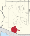 4200R Tohono O'odham Nation Reservation Locator Map.svg 1,150 × 1,357; 3.97 MB
-
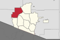
 Baboquivari District in the Tohono O'odham Nation.svg 531 × 354; 853 KB
-
 Chukut Kuk District in the Tohono O'odham Nation.svg 531 × 354; 853 KB
-
 Flag of the Gu Achi District, Tohono O'odham Nation.svg 512 × 391; 24 KB
-
 Gu Achi District in the Tohono O'odham Nation.svg 531 × 354; 853 KB
-
 Gu Vo District in the Tohono O'odham Nation.svg 512 × 441; 1.18 MB
-
 Hashan Chuchg AZ Gate to Mexico left open - panoramio.jpg 922 × 691; 42 KB
-
 Hickiwan District in the Tohono O'odham Nation.svg 531 × 354; 853 KB
-
 Map of the Districts of the Tohono O'odham Nation.svg 512 × 441; 1.21 MB
-

-

-

-
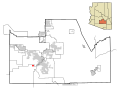
 Pima County Incorporated and Unincorporated areas Pisinemo highlighted.svg 1,100 × 700; 60 KB
-
 Pima County Incorporated and Unincorporated areas Santa Rosa highlighted.svg 1,100 × 700; 60 KB
-

-
-

-

-
 Pisinemo District in the Tohono O'odham Nation.svg 531 × 354; 853 KB
-
 San Lucy District in the Tohono O'odham Nation.svg 531 × 354; 853 KB
-
 San Xavier District in the Tohono O'odham Nation.svg 531 × 354; 853 KB
-
 San-Miguel-Gate.jpg 4,272 × 2,848; 3.4 MB
-
 Schuk Toak District in the Tohono O'odham Nation.svg 531 × 354; 853 KB
-
 Seal of the Hikiwan District, Tohono O'odham Nation.svg 512 × 516; 46 KB
-
 Sells District in the Tohono O'odham Nation.svg 531 × 354; 1.73 MB
-
 Shrine at Covered Wells, Arizona.jpg 1,536 × 862; 1.81 MB
-
 Sif Oidak District in the Tohono O'odham Nation.svg 531 × 354; 853 KB
-
 South of Chuichu.jpg 3,742 × 1,438; 1.53 MB
-
 Ventana Cave.jpg 300 × 432; 27 KB


