Category:Tonge, Kent
Main Wikipedia article: Tonge, Kent.

village and civil parish in Kent, UK  | |||||
| Upload media | |||||
| Instance of | |||||
|---|---|---|---|---|---|
| Location | Swale, Kent, South East England, England | ||||
 | |||||
Subcategories
This category has the following 3 subcategories, out of 3 total.
Media in category "Tonge, Kent"
The following 200 files are in this category, out of 312 total.
(previous page) (next page)-

-
 A footpath near Lynsted - geograph.org.uk - 4814031.jpg 640 × 480; 72 KB
-
 An old orchard on Dully Road - geograph.org.uk - 4814038.jpg 640 × 471; 93 KB
-
 Apple orchard near Wilford Court Farm - geograph.org.uk - 6244497.jpg 3,269 × 2,452; 1.6 MB
-
 Apple orchard opposite Wilford Court Farm - geograph.org.uk - 6243218.jpg 3,747 × 2,811; 2.09 MB
-

-

-
 Bapchild Cricket Club - geograph.org.uk - 1953058.jpg 3,072 × 2,304; 1.46 MB
-
 Barge at Conyer - geograph.org.uk - 3029789.jpg 640 × 430; 81 KB
-
 Barge, Conyer Creek - geograph.org.uk - 3029746.jpg 640 × 430; 91 KB
-
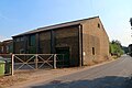
 Barn near Bunce's Farm - geograph.org.uk - 6168812.jpg 1,024 × 768; 400 KB
-
 Barns by Blacketts Farm - geograph.org.uk - 3708618.jpg 3,488 × 2,616; 2.26 MB
-
 Beacon, The Swale - geograph.org.uk - 3024143.jpg 640 × 430; 59 KB
-
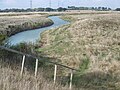
 Bend in a drainage ditch - geograph.org.uk - 3024225.jpg 640 × 430; 70 KB
-
-
 Blacketts Road, near Tonge - geograph.org.uk - 3708621.jpg 3,488 × 2,616; 2.21 MB
-
 Blacketts Road, near Tonge - geograph.org.uk - 3708622.jpg 3,488 × 2,616; 1.84 MB
-
 Boats at Conyer Creek - geograph.org.uk - 3708550.jpg 3,488 × 2,616; 2.13 MB
-
 Boats in the mud, Conyer Creek - geograph.org.uk - 3029743.jpg 640 × 430; 81 KB
-
 Boats, Conyer Creek - geograph.org.uk - 3029747.jpg 640 × 430; 96 KB
-
 Borrow dyke east of Elmley Ferry - geograph.org.uk - 6168708.jpg 1,024 × 768; 453 KB
-
 Bridleway to Conyer - geograph.org.uk - 1073600.jpg 481 × 640; 93 KB
-

-
-
 Cheke's Court at Tonge - geograph.org.uk - 6244469.jpg 4,000 × 3,000; 4.65 MB
-
-
 Church Road, Tonge - geograph.org.uk - 6243244.jpg 4,000 × 3,000; 4.68 MB
-

-
 Converted oast house in Radfield - geograph.org.uk - 5012309.jpg 1,960 × 1,412; 752 KB
-
 Conyer Creek - geograph.org.uk - 3028132.jpg 640 × 430; 77 KB
-
 Conyer Creek - geograph.org.uk - 3028156.jpg 640 × 430; 66 KB
-
 Conyer Creek - geograph.org.uk - 3028226.jpg 640 × 430; 59 KB
-
 Conyer Creek - geograph.org.uk - 3028250.jpg 640 × 430; 68 KB
-
 Conyer Creek - geograph.org.uk - 3029730.jpg 640 × 401; 59 KB
-
 Conyer Creek - geograph.org.uk - 3029740.jpg 640 × 430; 83 KB
-
 Conyer Creek - geograph.org.uk - 3029744.jpg 640 × 430; 82 KB
-
 Conyer Creek - geograph.org.uk - 3029780.jpg 640 × 430; 64 KB
-
 Conyer Creek - geograph.org.uk - 3708527.jpg 3,488 × 2,616; 2.14 MB
-
 Conyer Creek - geograph.org.uk - 3708531.jpg 3,488 × 2,616; 2.11 MB
-
 Conyer Creek - geograph.org.uk - 3708533.jpg 3,488 × 2,616; 2.26 MB
-
 Conyer Creek - geograph.org.uk - 3708544.jpg 3,488 × 2,616; 1.67 MB
-
 Conyer Creek - geograph.org.uk - 3708548.jpg 3,488 × 2,616; 1.79 MB
-
 Conyer Creek - geograph.org.uk - 3708613.jpg 3,488 × 2,616; 1.53 MB
-
 Conyer Creek - geograph.org.uk - 4489905.jpg 2,272 × 1,704; 758 KB
-
 Conyer Creek - geograph.org.uk - 5154340.jpg 4,608 × 3,456; 3.36 MB
-
 Conyer Creek - geograph.org.uk - 6249763.jpg 5,184 × 3,456; 1.44 MB
-
 Conyer Creek - geograph.org.uk - 6249765.jpg 5,184 × 3,456; 1.6 MB
-
 Conyer Creek entering The Swale - geograph.org.uk - 3024240.jpg 640 × 430; 52 KB
-
 Conyer Creek entering The Swale - geograph.org.uk - 3028106.jpg 640 × 430; 46 KB
-

-
 Cottage next to Cheke's Court - geograph.org.uk - 6243879.jpg 4,000 × 3,000; 4.93 MB
-
 Creeks in the mud - geograph.org.uk - 3020094.jpg 640 × 430; 58 KB
-
 Crossing over the railway - geograph.org.uk - 4972682.jpg 4,608 × 3,456; 3.34 MB
-
 Crossing to Bax Farm - geograph.org.uk - 4972718.jpg 4,608 × 3,456; 3.37 MB
-
 Disused rifle range - geograph.org.uk - 6168362.jpg 1,024 × 768; 430 KB
-

-
 Drainage channel - geograph.org.uk - 3020093.jpg 640 × 430; 46 KB
-
 Drainage channel - geograph.org.uk - 3021726.jpg 640 × 430; 73 KB
-
 Drainage channel - geograph.org.uk - 3021753.jpg 640 × 430; 62 KB
-
 Drainage channels - geograph.org.uk - 3020083.jpg 640 × 430; 80 KB
-
 Drainage ditch - geograph.org.uk - 3021751.jpg 640 × 430; 45 KB
-
 Drainage ditch - geograph.org.uk - 3024190.jpg 640 × 430; 67 KB
-
 Drainage ditch - geograph.org.uk - 3024213.jpg 640 × 430; 69 KB
-
 Drainage ditch - geograph.org.uk - 3029724.jpg 640 × 403; 59 KB
-
 Drainage ditch at the head of Conyer Creek - geograph.org.uk - 5154451.jpg 4,608 × 3,456; 3.56 MB
-
 Drainage ditch near Conyer - geograph.org.uk - 3029732.jpg 640 × 430; 69 KB
-
 Drainage ditch near Conyer - geograph.org.uk - 3031885.jpg 640 × 430; 73 KB
-
 Drainage ditch, grazing marshes - geograph.org.uk - 3024154.jpg 640 × 430; 59 KB
-
 Drainage ditches near Conyer - geograph.org.uk - 3708477.jpg 3,488 × 2,616; 2.22 MB
-
 Dry ditch - geograph.org.uk - 3029725.jpg 640 × 430; 101 KB
-
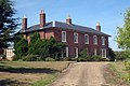
 Dully House, near Bapchild - geograph.org.uk - 4814013.jpg 640 × 480; 136 KB
-
 Dully House, near Bapchild - geograph.org.uk - 4814019.jpg 640 × 465; 74 KB
-
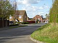
 Dully Road - geograph.org.uk - 5320009.jpg 640 × 480; 131 KB
-
 Dully Road - geograph.org.uk - 6191575.jpg 4,000 × 3,000; 4.76 MB
-
 Dully Road - geograph.org.uk - 6243116.jpg 4,000 × 3,000; 4.85 MB
-
 Dully Road - geograph.org.uk - 6243119.jpg 4,000 × 3,000; 4.91 MB
-
 Dully Road, Dully - geograph.org.uk - 3698459.jpg 3,488 × 2,616; 2.17 MB
-
 Dully Road, near Bapchild - geograph.org.uk - 3698402.jpg 3,488 × 2,616; 2.26 MB
-
 Dully Road, near Bapchild - geograph.org.uk - 3698441.jpg 3,488 × 2,616; 2.23 MB
-
 Dully Road, Tonge (geograph 5016128).jpg 3,264 × 2,448; 1.88 MB
-
 Dully Road, Tonge - geograph.org.uk - 5016103.jpg 3,264 × 2,448; 1.64 MB
-
 Dully Road, Tonge - geograph.org.uk - 5016109.jpg 3,264 × 2,448; 1.84 MB
-
 Dully Road, Tonge - geograph.org.uk - 5016121.jpg 3,264 × 2,448; 1.73 MB
-
 Elmley buoy, The Swale - geograph.org.uk - 6168108.jpg 1,024 × 768; 469 KB
-

-
 Entrance to Tonge Corner Farm - geograph.org.uk - 1016599.jpg 640 × 480; 75 KB
-
 Farm track near Tonge Corner - geograph.org.uk - 3708392.jpg 3,488 × 2,616; 2.24 MB
-
-
 Farmland by Lower Rd - geograph.org.uk - 3163527.jpg 640 × 430; 51 KB
-
 Farmland near Tonge - geograph.org.uk - 3163559.jpg 640 × 430; 69 KB
-
 Farmland south of Lower Rd - geograph.org.uk - 3163537.jpg 640 × 430; 43 KB
-
 Fence ending in a drainage channel - geograph.org.uk - 3021832.jpg 640 × 430; 61 KB
-
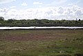
 Field and railway by Lower Road - geograph.org.uk - 6264366.jpg 5,184 × 3,456; 1.74 MB
-
 Field by Lower Road, Bapchild - geograph.org.uk - 5040011.jpg 2,304 × 1,728; 792 KB
-
 Field by Lower Road, Bapchild - geograph.org.uk - 5040017.jpg 2,304 × 1,728; 816 KB
-
 Fields next to Panteny Lane, Bapchild - geograph.org.uk - 4973482.jpg 4,608 × 3,456; 3.4 MB
-
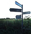 Finger Post, Tonge - geograph.org.uk - 3709642.jpg 2,258 × 2,498; 1,011 KB
-
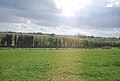
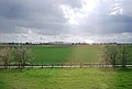 Flat farmland - geograph.org.uk - 3163535.jpg 640 × 430; 47 KB
-

-
 Flooding on Church Road - geograph.org.uk - 1600787.jpg 640 × 427; 46 KB
-
 Footpath approaching Conyer - geograph.org.uk - 6249760.jpg 5,184 × 3,456; 1.55 MB
-
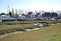
 Footpath past Conyer Marina - geograph.org.uk - 6249767.jpg 5,184 × 3,456; 1.68 MB
-
 Footpath to Lynsted - geograph.org.uk - 4814063.jpg 640 × 462; 112 KB
-
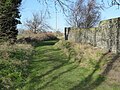 Footpath to Panteny Lane, near Bapchild - geograph.org.uk - 4814009.jpg 640 × 480; 128 KB
-
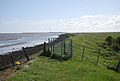
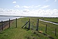
 Gate, Saxon Shore Way - geograph.org.uk - 3020052.jpg 640 × 430; 73 KB
-
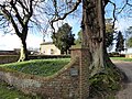
 Gravestones in St Giles Churchyard, Tonge - geograph.org.uk - 6244451.jpg 3,373 × 2,529; 2.91 MB
-
 Grazing marshes - geograph.org.uk - 3021754.jpg 640 × 430; 61 KB
-
 Grazing marshes - geograph.org.uk - 3021857.jpg 640 × 430; 62 KB
-
 Grazing marshes and drainage ditch - geograph.org.uk - 3020061.jpg 640 × 430; 87 KB
-
 Grazing marshes north of Blacketts - geograph.org.uk - 3021781.jpg 640 × 418; 50 KB
-
 Grazing marshes north of Blacketts - geograph.org.uk - 3021822.jpg 640 × 430; 53 KB
-
 Grazing marshes south of The Swale - geograph.org.uk - 3020072.jpg 640 × 430; 65 KB
-
 Grazing marshes west of Conyer - geograph.org.uk - 3028204.jpg 640 × 421; 47 KB
-
 High water at Conyer Creek - geograph.org.uk - 2564848.jpg 4,000 × 3,000; 2.25 MB
-
 Horse amidst buttercups - geograph.org.uk - 6191442.jpg 3,711 × 2,912; 2.7 MB
-
 Horse and buttercups - geograph.org.uk - 6191439.jpg 4,000 × 3,000; 4.52 MB
-
 Horses in a field of buttercups - geograph.org.uk - 6190695.jpg 4,000 × 3,000; 4.94 MB
-
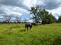 Horses next to Wood Street in a field of buttercups - geograph.org.uk - 6191435.jpg 4,000 × 3,000; 4.77 MB
-
 House at Tong Corner Farm - geograph.org.uk - 1449760.jpg 640 × 427; 100 KB
-
 Houseboat, Conyer Creek - geograph.org.uk - 3029794.jpg 640 × 430; 77 KB
-
 Houses along Conyer Creek - geograph.org.uk - 3029784.jpg 640 × 430; 59 KB
-
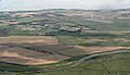
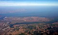 Isle of Sheppey from the Air - geograph.org.uk - 2668462.jpg 1,024 × 619; 182 KB
-

-
 Kissing Gate on the Saxon Shore Way by the Swale - geograph.org.uk - 3708464.jpg 3,488 × 2,616; 2.2 MB
-
 Kissing gate, Saxon Shore Way - geograph.org.uk - 3021746.jpg 640 × 430; 67 KB
-
 Kissing gate, Saxon Shore Way - geograph.org.uk - 3024187.jpg 640 × 430; 61 KB
-
 Kissing gate, Saxon Shore Way - geograph.org.uk - 3031878.jpg 640 × 430; 86 KB
-
 Lane between Little Murston and Tonge Corner - geograph.org.uk - 3708398.jpg 3,488 × 2,616; 3.3 MB
-

-
 Level crossing to Bax Farm - geograph.org.uk - 5428523.jpg 640 × 428; 167 KB
-
 Linear pond by Conyer Creek - geograph.org.uk - 3029742.jpg 640 × 430; 74 KB
-
 Little Dully Cottages - geograph.org.uk - 1449722.jpg 640 × 427; 86 KB
-
 Little Dully Cottages - geograph.org.uk - 3698446.jpg 3,488 × 2,616; 1.82 MB
-
 Localised flooding - geograph.org.uk - 3020079.jpg 640 × 403; 50 KB
-
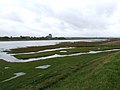
 Localised flooding on the marshes - geograph.org.uk - 3024150.jpg 640 × 430; 64 KB
-
 Lomas Road - geograph.org.uk - 4413988.jpg 640 × 480; 160 KB
-
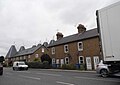
 London Road, Bapchild - geograph.org.uk - 5005657.jpg 2,048 × 1,536; 1,016 KB
-
 London Road, Bapchild - geograph.org.uk - 5012321.jpg 1,976 × 1,436; 729 KB
-
 London Road, Bapchild - geograph.org.uk - 5012325.jpg 1,958 × 1,410; 654 KB
-
 Looking across Conyer Creek - geograph.org.uk - 5159001.jpg 4,608 × 3,456; 3.32 MB
-
 Looking towards Tonge Corner Farm - geograph.org.uk - 6244477.jpg 4,000 × 3,000; 4.75 MB
-
 Low tide at Conyer - geograph.org.uk - 6249758.jpg 5,184 × 3,456; 1.79 MB
-
 Low tide, Conyer Creek - geograph.org.uk - 3028104.jpg 640 × 430; 65 KB
-
 Low tide, The Swale - geograph.org.uk - 3021734.jpg 640 × 430; 52 KB
-
 Marshes behind sea wall - geograph.org.uk - 6168310.jpg 1,024 × 768; 413 KB
-
 Marshes by Conyer Creek - geograph.org.uk - 3028238.jpg 640 × 430; 76 KB
-
 Marshes north of Blacketts - geograph.org.uk - 3021777.jpg 640 × 430; 53 KB
-
 Marshes, Conyer Creek - geograph.org.uk - 3028144.jpg 640 × 430; 88 KB
-
 Marshes, Conyer Creek - geograph.org.uk - 3028231.jpg 640 × 430; 88 KB
-
 Memorial Way, from Tonge Mill - geograph.org.uk - 1004087.jpg 640 × 481; 91 KB
-

-
 Mill House, Church Road, Tonge, Kent - geograph.org.uk - 1449739.jpg 640 × 427; 82 KB
-
 Moorings at Conyer - geograph.org.uk - 6249759.jpg 5,184 × 3,456; 1.92 MB
-
 Mouth of Conyer Creek - geograph.org.uk - 5429664.jpg 640 × 480; 114 KB
-
 Mud, Conyer Creek - geograph.org.uk - 3028136.jpg 640 × 430; 65 KB
-
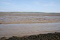
 Mud, The Swale - geograph.org.uk - 3020046.jpg 640 × 430; 61 KB
-
 Mud, The Swale - geograph.org.uk - 3020075.jpg 640 × 430; 54 KB
-
 Mud, The Swale - geograph.org.uk - 3021868.jpg 640 × 430; 51 KB
-
 Mudbank, The Swale - geograph.org.uk - 3021827.jpg 640 × 430; 54 KB
-
 Mudbank, The Swale - geograph.org.uk - 3024163.jpg 640 × 430; 42 KB
-
 Mudbanks, The Swale - geograph.org.uk - 3020059.jpg 640 × 430; 58 KB
-
 Mudflats, The Swale - geograph.org.uk - 3020086.jpg 640 × 430; 59 KB
-
 Mudflats, The Swale - geograph.org.uk - 3020089.jpg 640 × 430; 52 KB
-
 Mudflats, The Swale - geograph.org.uk - 3021730.jpg 640 × 430; 50 KB
-
 Mudflats, The Swale - geograph.org.uk - 3024134.jpg 640 × 430; 57 KB
-
 Narrowboat, Swale Marina - geograph.org.uk - 3031864.jpg 640 × 430; 100 KB
-

-
 Navigating Conyer Creek - geograph.org.uk - 5429661.jpg 640 × 480; 123 KB
-
 New Cottages, Dully - geograph.org.uk - 3698453.jpg 3,488 × 2,616; 1.77 MB
-
 Oast House - geograph.org.uk - 6248915.jpg 5,184 × 3,456; 1.4 MB
-
 Old oast houses in Radfield - geograph.org.uk - 5012270.jpg 1,930 × 1,362; 658 KB
-
 Orchards by Lower Rd - geograph.org.uk - 3163541.jpg 640 × 430; 58 KB
-
 Orchards near Tonge - geograph.org.uk - 3163551.jpg 640 × 430; 56 KB
-

-
 Panteny Lane, Bapchild - geograph.org.uk - 3698381.jpg 3,488 × 2,616; 2.32 MB
-
 Panteny Lane, Bapchild - geograph.org.uk - 4973480.jpg 4,608 × 3,456; 3.34 MB
-
 Panteny Lane, Bapchild - geograph.org.uk - 5320001.jpg 640 × 480; 145 KB
-
 Path and porch, Tonge church - geograph.org.uk - 6168743.jpg 1,024 × 768; 569 KB
-
 Path between water bodies - geograph.org.uk - 3029734.jpg 640 × 430; 71 KB
-

-
 Pond near The Swale - geograph.org.uk - 3020047.jpg 640 × 430; 96 KB
-
-
 Radfield House, London Road - geograph.org.uk - 5167252.jpg 3,264 × 2,448; 2.27 MB
-
 Radfield House, London Road - geograph.org.uk - 6004150.jpg 3,264 × 2,448; 3.83 MB
-
 Railway bridge near Tonge Mill - geograph.org.uk - 1016660.jpg 640 × 480; 87 KB
-
 Railway bridge over Church Road - geograph.org.uk - 4973593.jpg 4,608 × 3,456; 3.39 MB
-
 Railway bridge over Church Road - geograph.org.uk - 4973596.jpg 4,608 × 3,456; 3.34 MB
-
 Railway Bridge over Church Road, Tonge - geograph.org.uk - 3709640.jpg 3,488 × 2,616; 2.88 MB
-
 Railway bridge over Church Road, Tonge - geograph.org.uk - 6168838.jpg 1,024 × 684; 524 KB
-
 Reed choked ditch near Conyer Creek - geograph.org.uk - 3028120.jpg 640 × 389; 57 KB
-
 Reeds on Dyke in Teynham Levels - geograph.org.uk - 1221538.jpg 640 × 480; 97 KB
-
 Ripe apples near Wilford Court Farm - geograph.org.uk - 6244493.jpg 3,719 × 2,789; 2.1 MB
-
 Saxon Shore Way - geograph.org.uk - 3020068.jpg 640 × 430; 67 KB
-
 Saxon Shore Way - geograph.org.uk - 3020076.jpg 640 × 430; 58 KB
-
 Saxon Shore Way - geograph.org.uk - 3020088.jpg 640 × 430; 63 KB
-
 Saxon Shore Way - geograph.org.uk - 3024167.jpg 640 × 430; 56 KB
-
 Saxon Shore Way - geograph.org.uk - 3028128.jpg 640 × 430; 69 KB
-
 Saxon Shore Way - geograph.org.uk - 3029787.jpg 640 × 430; 61 KB
-
 Saxon Shore Way - geograph.org.uk - 3031855.jpg 640 × 430; 60 KB
-
 Saxon Shore Way along The Swale - geograph.org.uk - 3016174.jpg 640 × 430; 58 KB
_The_Arnhem_Oak,_Memorial_Way,_Tonge_Mill_Park_-_geograph.org.uk_-_1574059.jpg)


.jpg)


