Category:Topographic maps of Aust-Agder
Media in category "Topographic maps of Aust-Agder"
The following 20 files are in this category, out of 20 total.
-
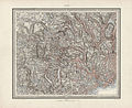
 Generalkart II, Kristiansand, 1869.jpg 7,046 × 5,728; 5.5 MB
-
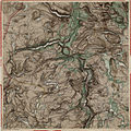
 Generalkart II, Kristiansand, 1929.jpg 6,446 × 5,735; 5.57 MB
-
 Generalkart V, Skien, 1877.jpg 7,046 × 5,728; 9.95 MB
-
 Generalkart V, Skien, 1916.jpg 6,550 × 5,631; 9.33 MB
-
 Generalkart V, Skien, 1931.jpg 6,415 × 5,624; 9.53 MB
-
 Kart over Nedenæs og Robygdelagets Amt (nord), 1858 - 1.jpg 10,358 × 6,896; 9.87 MB
-
 Kart over Nedenæs og Robygdelagets Amt (nord), 1858.jpg 9,862 × 6,572; 11.9 MB
-
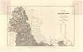 Kart over Nedenæs og Robygdelagets Amt (nord), 1900 -1.jpg 10,925 × 6,763; 10.42 MB
-
 Kart over Nedenæs og Robygdelagets Amt (nord), 1900.jpg 10,902 × 6,767; 10.2 MB
-
 Kart over Nedenæs og Robygdelagets Amt (sør) - (revidert), 1901.jpg 10,382 × 6,399; 9.63 MB
-
 Kart over Nedenæs og Robygdelagets Amt (sør), 1859.jpg 9,827 × 6,088; 13.36 MB
-
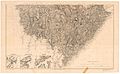
 Kroki over en del av Bykle- og Suldalsheierne, Høyfjellkommisjonen, 1916.jpg 7,598 × 6,080; 5.99 MB
-
 Kroki over en del av Bykle- og Suldalsheierne, Høyfjellkommisjonen, 1963.jpg 7,526 × 6,214; 6.46 MB
-
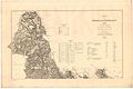
 Nedenes amt nr 12- Nedenæs og Robygdelagets Amt, 1859.jpg 8,176 × 4,925; 7.72 MB
-
 Portefølje nr 13, 1857.jpg 6,894 × 6,894; 8.75 MB
-
 Portefølje nr 20, 1860.jpg 6,934 × 6,933; 8 MB
-
 Portefølje nr 3, 1858.jpg 6,880 × 6,951; 7.59 MB
-
 Portefølje nr 6, 1858.jpg 6,831 × 6,895; 10.14 MB
-
 Portefølje nr 7, 1859.jpg 6,887 × 6,983; 9.1 MB
-
 Portefølje nr 8, 1856.jpg 6,848 × 6,943; 7.69 MB


,_1858_-_1.jpg)
,_1858.jpg)
,_1900_-1.jpg)
,_1900.jpg)
_-_(revidert),_1901.jpg)
,_1859.jpg)


