Category:Topographic maps of Corfu
Media in category "Topographic maps of Corfu"
The following 15 files are in this category, out of 15 total.
-
 Carta Topografica Dell' Isola di Corfu.jpg 8,767 × 4,669; 11.81 MB
-
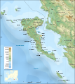
 Corfu topographic map-blank.svg 2,100 × 2,345; 2.29 MB
-
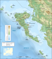
 Corfu topographic map-de.svg 2,100 × 2,345; 2.43 MB
-
 Corfu topographic map-es.svg 2,100 × 2,345; 2.49 MB
-
 Corfu topographic map-fr.svg 2,100 × 2,345; 2.46 MB
-
 Corfu topographic map-mk.svg 2,100 × 2,345; 2.45 MB
-
 Corfu topographic map-nb.svg 2,100 × 2,345; 2.46 MB
-
 Corfu Channel topographic map-en.svg 595 × 755; 2.23 MB
-
 Corfu topographic map-be.svg 2,100 × 2,345; 2.43 MB
-
 Corfu topographic map-el.svg 2,100 × 2,345; 2.45 MB
-
 Corfu topographic map-en librsvg.png 2,096 × 2,341; 2.1 MB
-
 Corfu topographic map-en rendersvg.png 2,096 × 2,341; 2.7 MB
-
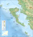
 Corfu topographic map-en.svg 2,096 × 2,341; 2.19 MB
-
 Corfu topographic map-hu.svg 2,100 × 2,345; 2.47 MB
-
 Corfu topographic map-Stad.PNG 324 × 162; 51 KB


