Category:Topographic maps of Easter Island
Media in category "Topographic maps of Easter Island"
The following 17 files are in this category, out of 17 total.
-
 Easter Island Ahu Akivi.png 1,750 × 1,245; 879 KB
-
 Easter Island map-be.svg 1,750 × 1,245; 533 KB
-
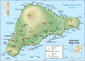
 Easter Island map-by.png 1,750 × 1,245; 579 KB
-
 Easter Island map-de.svg 1,750 × 1,245; 856 KB
-
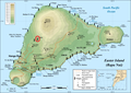
 Easter Island map-en.svg 1,750 × 1,245; 878 KB
-
 Easter Island map-es.svg 1,750 × 1,245; 537 KB
-
 Easter Island map-fr.svg 1,750 × 1,245; 878 KB
-
 Easter Island map-HE.svg 1,750 × 1,245; 917 KB
-
 Easter Island map-hu.svg 1,750 × 1,245; 877 KB
-
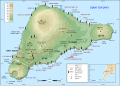
 Easter Island map-it.svg 1,750 × 1,245; 537 KB
-
 Easter Island map-ka.svg 1,750 × 1,245; 878 KB
-
 Easter Island map-mk.svg 1,750 × 1,245; 879 KB
-
 Easter Island map-nl.svg 1,750 × 1,245; 535 KB
-
 Easter Island map-ru.svg 1,750 × 1,245; 538 KB
-
 Easter Island map-sr.svg 1,750 × 1,245; 537 KB
-
 Easter Island map-uk.svg 1,427 × 1,019; 551 KB
-
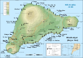
 Easter Island relief map.svg 1,750 × 1,245; 499 KB


