Category:Topographic maps of New Zealand
Subcategories
This category has only the following subcategory.
*
Media in category "Topographic maps of New Zealand"
The following 67 files are in this category, out of 67 total.
-
 Auckland Islands New Zealand geographic map en.svg 1,800 × 2,274; 2.37 MB
-
 Auckland islands topo.png 1,133 × 1,507; 867 KB
-
 Bounty Islands New Zealand geographic map en.svg 2,420 × 1,800; 102 KB
-
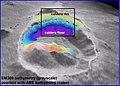
 Brothers Volcano - map00258.jpg 1,744 × 1,224; 239 KB
-
 Brothers Volcano - map00259.jpg 2,716 × 1,872; 766 KB
-
 Brothers Volcano - map00260.jpg 2,713 × 1,958; 582 KB
-
 Brothers Volcano - map00262.jpg 2,674 × 1,836; 310 KB
-
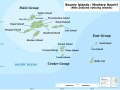
 Campbell Island New Zealand geographic map en.svg 1,005 × 1,000; 755 KB
-
 Carte Auckland Region-fr.svg 724 × 805; 1.14 MB
-
 Carte Auckland Region.png 722 × 802; 706 KB
-
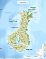
 Carte ile du Nord NZ.png 823 × 911; 569 KB
-
 Carte ile du Sud NZ.png 1,114 × 910; 637 KB
-
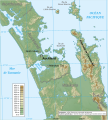
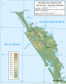
 Carte physique Northland.png 756 × 957; 422 KB
-
 Carte physique Northland.svg 754 × 954; 3.12 MB
-
 Carte topographique de Niue.svg 1,760 × 2,005; 332 KB
-
 Chatham-Island map topo en.png 1,109 × 972; 139 KB
-
 Chatham-Islands map topo de.svg 1,669 × 1,425; 665 KB
-
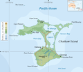
 Chatham-Islands map topo en.svg 1,669 × 1,425; 758 KB
-
 Chatham-Islands map topo-fr.svg 1,669 × 1,425; 746 KB
-
 Chatham-Islands map topo-mk.svg 1,669 × 1,425; 1.3 MB
-
 DEM NewZealand.png 3,120 × 2,462; 2.28 MB
-
 Fiordland relief location map.png 980 × 1,234; 859 KB
-
 Lake Alexandrina, New Zealand map.png 1,185 × 667; 1.33 MB
-
 Lake Alexandrina, New Zealand.png 624 × 701; 524 KB
-
 Map New Zealand-be.svg 1,313 × 1,618; 416 KB
-
 Map New Zealand-el.svg 1,313 × 1,618; 1.27 MB
-
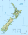
 Map New Zealand-en.svg 1,313 × 1,618; 1.51 MB
-
 Map New Zealand-es.svg 1,623 × 2,000; 1.22 MB
-
 Map New Zealand-fr.svg 1,313 × 1,618; 1.47 MB
-
 Map New Zealand-mk.svg 1,623 × 2,000; 883 KB
-
 Map of New Zealand, Christchurch Botanical Gardens.jpg 4,222 × 3,188; 3.16 MB
-
 Marlborough Sounds topographic map-en.svg 3,971 × 4,208; 13.18 MB
-
 Marlborough Sounds topographic map-fr.svg 3,971 × 4,208; 13.19 MB
-
 NASA fiordland 2009 earthquake.png 720 × 480; 363 KB
-
 New Zealand (relief map).png 1,380 × 1,976; 556 KB
-
 New Zealand Cities.PNG 618 × 792; 595 KB
-
 New Zealand earthquake 2007.png 418 × 512; 167 KB
-
 New Zealand Physiography.jpg 1,981 × 2,596; 1 MB
-
 New Zealand relief map.jpg 1,200 × 1,514; 185 KB
-
 New Zealand South Island 41to47S 167to173E Topo Rainbow Zebra 1326.jpg 7,200 × 7,200; 20.6 MB
-
 New Zealand topographic map.jpg 652 × 904; 41 KB
-
 New Zealand Topography.jpg 4,500 × 5,800; 1.21 MB
-
 Ngāi Tahu Takiwa.jpg 599 × 807; 104 KB
-
 Niue-topo50-maps + modern borders.svg 5,671 × 8,505; 7.26 MB
-
 Niue-topo50-maps.jpg 5,671 × 8,505; 5.28 MB
-
 NZ Banks Peninsula relief location map.svg 1,820 × 1,800; 1.63 MB
-
 NZ Fiordland relief location map.svg 2,600 × 3,696; 6.56 MB
-
 NZ Marlborough Sounds relief location map.svg 2,600 × 3,445; 3.87 MB
-
 Pacific Ocean surface 3.jpg 1,119 × 940; 222 KB
-
 Pitt-Island map topo en.png 838 × 620; 70 KB
-
 Position of Wanganui District.png 230 × 282; 131 KB
-
 Snares Islands New Zealand geographic map en.svg 2,751 × 1,800; 195 KB
-
 Solander Islands New Zealand geographic map en.svg 2,851 × 1,800; 91 KB
-
 Tasman Sea.jpg 919 × 642; 98 KB
-
 Three Kings Islands New Zealand geographic map en.svg 1,765 × 1,000; 944 KB
-
 Topographical map of the Antipodes Islands in English.svg 1,242 × 980; 164 KB
-
 Topographical map of the Antipodes Islands in German.svg 1,242 × 980; 165 KB
-
 Topographical map of the Antipodes Islands in Macedonian.svg 1,242 × 980; 164 KB
-
 Topography of new zealand.jpg 540 × 696; 86 KB
-
 Volcansnouvellezelande.png 1,917 × 2,470; 868 KB
-
 Wairau River Map.jpg 400 × 340; 77 KB
-
 Wallace Island Life p472.png 1,481 × 1,142; 39 KB
-
 Zealandia-Continent map en.svg 789 × 864; 327 KB
-
 Zealandia-Continent map fr.svg 794 × 868; 339 KB
-
 Zealandia-Continent map mk.svg 789 × 864; 454 KB
-
 Округа Ниуэ.svg 1,721 × 2,000; 271 KB
-
 Физичка карта на Ниуе.svg 1,760 × 2,005; 332 KB


.png)


