Category:Topographic maps of Saint-André-de-Majencoules
Media in category "Topographic maps of Saint-André-de-Majencoules"
The following 4 files are in this category, out of 4 total.
-
 30229-Saint-André-de-Majencoules-argile.png 3,057 × 2,480; 5.94 MB
-
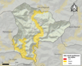
 30229-Saint-André-de-Majencoules-Natura2000.png 5,846 × 4,133; 16.11 MB
-
 30229-Saint-André-de-Majencoules-ZNIEFF1.png 4,692 × 3,307; 11.67 MB
-
 30229-Saint-André-de-Majencoules-ZNIEFF2.png 3,519 × 2,480; 6.97 MB


