Category:Topographic maps of historic castles
Media in category "Topographic maps of historic castles"
The following 16 files are in this category, out of 16 total.
-
 Alt-Sternberg.png 1,200 × 616; 902 KB
-
 Amelungsburg Plan.jpg 1,602 × 1,549; 1.41 MB
-
 Babilonie Plan1916.jpeg 1,212 × 1,737; 1.37 MB
-
 Burg-Schildberg-Lügde.jpg 1,048 × 1,139; 288 KB
-
 Grotenburg-Hühnenring-Plan.jpg 1,741 × 1,425; 1.59 MB
-
 Herlingsburg.png 699 × 615; 531 KB
-
 Hölzermann - Die Hünengräben bei Kirch Borchen.jpg 2,116 × 3,084; 2.06 MB
-
 Lageplan-Alt-Schieder-.jpg 1,969 × 1,778; 1.18 MB
-
 Löwenburg-Hünensaut-nach-Carl-Schuchhardt.jpg 1,163 × 1,117; 675 KB
-
 Piepenkopf.png 631 × 555; 588 KB
-
 Plan-Bomhof-Lügde.jpg 1,575 × 1,538; 813 KB
-
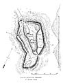
 Plan-Burg-Alt-Sternberg.jpg 1,575 × 1,386; 813 KB
-
 Plan-Siekholzer-Schanze.jpg 1,772 × 1,684; 928 KB
-
 Rapolanvuori piirros.jpg 425 × 554; 86 KB
-
 Tönsberg-Wallburg.jpg 1,969 × 1,235; 1.02 MB
-
 Uffoburg-Plan.jpg 1,644 × 1,407; 1.59 MB


