Category:Topographic maps of the Isle of Man
Media in category "Topographic maps of the Isle of Man"
The following 12 files are in this category, out of 12 total.
-
 Isle of Man railway map-de.svg 1,200 × 1,100; 274 KB
-
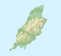 Isle of Man relief location map.svg 1,200 × 1,100; 340 KB
-
 Isle of Man topographic map-de.svg 1,200 × 1,100; 334 KB
-
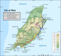
 Isle of Man topographic map-en.svg 1,200 × 1,100; 642 KB
-
 Isle of Man topographic map-fr.svg 1,200 × 1,100; 644 KB
-
 Isle of Man topographic map-hu.svg 1,200 × 1,100; 645 KB
-
 Isle of Man topographic map-it.svg 1,200 × 1,100; 745 KB
-
 Isle of Man topographic map-mk.svg 1,200 × 1,100; 644 KB
-
 Isle of Man topographic map-nb.svg 1,200 × 1,100; 643 KB
-
 Isle of Man topographic map-ru.svg 1,200 × 1,100; 644 KB
-
 The birds of the Isle of Man BHL48037974.jpg 2,695 × 3,501; 1.15 MB
-
 Востраў Мэн.svg 1,200 × 1,100; 605 KB


