Category:Topographic maps of the Seine basin
Media in category "Topographic maps of the Seine basin"
The following 9 files are in this category, out of 9 total.
-
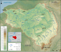
 Bassin Seine.png 3,500 × 3,007; 6.72 MB
-
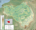
 Topographic map of the Seine basin (English png).png 3,484 × 2,987; 7.64 MB
-
 Topographic map of the Seine basin (Esperanto- png).png 3,477 × 2,987; 7.67 MB
-
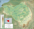
 Topographic map of the Seine basin (French png).png 3,500 × 3,007; 7.71 MB
-
 Topographic map of the Seine basin.svg 1,155 × 992; 5.2 MB
-
 Topographic map of the Seine basin (English).svg 1,155 × 992; 5.39 MB
-
 Topographic map of the Seine basin (Esperanto).svg 1,155 × 992; 5.4 MB
-
 Topographic map of the Seine basin (he).svg 1,155 × 992; 5.41 MB
-
 Topographic map of the Seine basin es.svg 1,155 × 992; 5.49 MB

.png)
.png)
.png)

.svg)
.svg)
.svg)
