Category:Torre Rodona (Riudaura)
| Object location | | View all coordinates using: OpenStreetMap |
|---|
cultural property in Riudaura, Spain  | |||||
| Upload media | |||||
| Instance of | |||||
|---|---|---|---|---|---|
| Location | Riudaura, Garrotxa, Province of Girona, Catalonia | ||||
| Street address |
| ||||
| Architectural style | |||||
| Heritage designation | |||||
| Inception |
| ||||
| Elevation above sea level |
| ||||
 | |||||
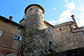
Català: Torre Rodona. Pl. de l'Església (Riudaura)
This is a category about a monument listed in the Catalan heritage register of Béns Culturals d'Interès Nacional and the Spanish heritage register of Bienes de Interés Cultural under the reference RI-51-0006048. |
Media in category "Torre Rodona (Riudaura)"
The following 3 files are in this category, out of 3 total.
-
 Ridaura, església de Santa Maria, torre, i cases veïnes.jpg 1,200 × 863; 258 KB
-
 Torre de Ridaura 1.jpg 534 × 800; 174 KB
-
 Torre de Ridaura 2.jpg 800 × 534; 117 KB

