Category:Tortilla Flat, Arizona
unincorporated community in Maricopa County, Arizona, United States   | |||||
| Upload media | |||||
| Instance of | |||||
|---|---|---|---|---|---|
| Location | Maricopa County, Arizona | ||||
 | |||||
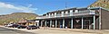
English: Tortilla Flat, Arizona is an unincorporated community in the Superstition Mountains in eastern Maricopa County, Arizona, located along the Apache Trail (Arizona State Route 88). With an unofficial population of 6, it originated as a campground for prospectors, and later was a freight camp for the building of the Theodore Roosevelt Dam. It is now owned and operated by Alvin Ross, a farmer from Indiana who purchased the town – which consists primarily of a bar/restaurant, a country store and a mercantile/gift shop – in 1998.
Subcategories
This category has the following 6 subcategories, out of 6 total.
B
- Boulder Creek Bridge (5 F)
M
- Mormon Flat Bridge (2 F)
T
- Tortilla Flat Country Store (7 F)
- Tortilla Flat Museum (3 F)
Media in category "Tortilla Flat, Arizona"
The following 12 files are in this category, out of 12 total.
-
 2021 Tortilla Flat false front Harness and Buggy Repair Shop.jpg 3,206 × 3,690; 2.96 MB
-
 2021 Tortilla Flat from southwest - Schoolhouse, Store and Saloon.jpg 4,753 × 1,641; 1.5 MB
-
 2021 Tortilla Flat from southwest - Schoolhouse, Store, Saloon and Mercantile.jpg 4,811 × 1,533; 1.39 MB
-
 2021 Tortilla Flat outhouse.jpg 2,955 × 3,611; 2.95 MB
-
 2021 Tortilla Flat rock formation.jpg 5,136 × 3,746; 3.95 MB
-
 2021 Tortilla Flat sign.JPG 3,864 × 5,152; 4.24 MB
-
 Drink Up (5612247780).jpg 4,174 × 3,130; 4.39 MB
-
 Fish Creek Bridge.jpg 2,816 × 2,112; 1.86 MB
-
 Maricopa County Incorporated and Planning areas Tortilla Flat location.svg 940 × 812; 1.05 MB
-
 Reenacting a hanging at Tortilla Flat.jpg 3,421 × 2,876; 2.89 MB
-
 Tortilla Flat (29532041862).jpg 5,184 × 3,456; 8.51 MB
-
 Tortilla Flat (29532043922).jpg 5,184 × 3,456; 6.46 MB


.jpg)


.jpg)
.jpg)