Category:Town hall Altdorf
| Object location | | View all coordinates using: OpenStreetMap |
|---|
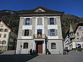
administrative building in Altdorf in the canton of Uri, Switzerland  | |||||
| Upload media | |||||
| Instance of | |||||
|---|---|---|---|---|---|
| Part of | |||||
| Location | Altdorf, Uri, Switzerland | ||||
| Street address |
| ||||
| Located on street |
| ||||
| Heritage designation | |||||
 | |||||
Media in category "Town hall Altdorf"
The following 2 files are in this category, out of 2 total.
-
 Altdorf Rathaus.JPG 2,816 × 2,112; 1.43 MB
-
 Rathaus30Sep18.jpg 2,304 × 3,456; 3.3 MB
