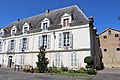
Category:Town hall of Aire-sur-l'Adour
| Object location | | View all coordinates using: OpenStreetMap |
|---|
|
This building is inscrit au titre des monuments historiques de la France. It is indexed in the base Mérimée, a database of architectural heritage maintained by the French Ministry of Culture, under the reference PA40000090
|
town hall located in Landes, in France  | |||||
| Upload media | |||||
| Instance of |
| ||||
|---|---|---|---|---|---|
| Location | Aire-sur-l'Adour, canton of Aire-sur-l'Adour | ||||
| Street address |
| ||||
| Owned by |
| ||||
| Operator | |||||
| Heritage designation |
| ||||
| Significant event |
| ||||
 | |||||
Media in category "Town hall of Aire-sur-l'Adour"
The following 6 files are in this category, out of 6 total.
-
 Aire sur l'Adour-Hôtel de ville.jpg 1,600 × 1,200; 383 KB
-
 Aire-sur-l'Adour - Mairie.jpg 811 × 517; 91 KB
-
 Aire-sur-l'Adour evêché (Brutails).jpg 434 × 600; 77 KB
-
-
 Aire-sur-l'Adour mairie 2019 6862.jpg 3,456 × 5,184; 7.54 MB
-
 Aire-sur-l'Adour mairie 2019 6863.jpg 5,184 × 3,456; 7.2 MB

.jpg)


