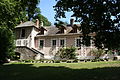
Category:Town hall of Fontaine-le-Port
| Object location | | View all coordinates using: OpenStreetMap |
|---|
 | |||||
| Upload media | |||||
| Instance of | |||||
|---|---|---|---|---|---|
| Location | Fontaine-le-Port, Seine-et-Marne, Île-de-France, Metropolitan France, France | ||||
| Street address |
| ||||
| Owned by | |||||
| Operator | |||||
 | |||||
Media in category "Town hall of Fontaine-le-Port"
The following 5 files are in this category, out of 5 total.
-
 Fontaine-le-Port Mairie 558.jpg 4,711 × 3,140; 12.98 MB
-
 Fontaine-le-Port Mairie 559.jpg 4,896 × 3,264; 15.93 MB
-
 Fontaine-le-Port Town hall 27.JPG 3,888 × 2,592; 8.98 MB
-
 Fontaine-le-Port Town hall 28.JPG 3,888 × 2,592; 9.87 MB
-
 Fontaine-le-Port Town hall 29.JPG 3,888 × 2,592; 9.94 MB


