Category:Town hall of Villers-Farlay
| Object location | | View all coordinates using: OpenStreetMap |
|---|
|
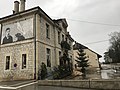
This building is inscrit au titre des monuments historiques de la France. It is indexed in the base Mérimée, a database of architectural heritage maintained by the French Ministry of Culture, under the reference PA39000065
|
_le_5_janvier_2018_-_8.JPG) | |||||
| Upload media | |||||
| Instance of | |||||
|---|---|---|---|---|---|
| Location | Villers-Farlay, canton of Villers-Farlay | ||||
| Street address |
| ||||
| Owned by | |||||
| Operator | |||||
| Heritage designation |
| ||||
 | |||||
Media in category "Town hall of Villers-Farlay"
The following 3 files are in this category, out of 3 total.
-
 Villers-Farlay (Jura) le 5 janvier 2018 - 4.JPG 4,032 × 3,024; 3.96 MB
-
 Villers-Farlay (Jura) le 5 janvier 2018 - 6.JPG 4,032 × 3,024; 3.67 MB
-
 Villers-Farlay (Jura) le 5 janvier 2018 - 8.JPG 4,032 × 3,024; 2.73 MB
_le_5_janvier_2018_-_4.JPG)
_le_5_janvier_2018_-_6.JPG)