Category:Tram maps of Rhode Island
Media in category "Tram maps of Rhode Island"
The following 24 files are in this category, out of 24 total.
-
-
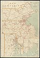
 Electric railway map of eastern New England. LOC 98688386.jpg 7,089 × 10,516; 12.27 MB
-
 Electric railway map of eastern New England. LOC 98688386.tif 7,089 × 10,516; 213.28 MB
-
 1901 Traveler's Map of Eastern New England.png 3,159 × 4,327; 22.59 MB
-
 1905 bird's eye view streetcar map of southern New England.jpg 4,000 × 2,723; 3.08 MB
-
 1907 bird's eye view of trolley routes in New England.jpg 6,672 × 9,580; 17.18 MB
-
 1908 bird's eye view of trolley routes in New England.jpg 4,439 × 6,366; 10.27 MB
-
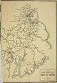
 1908 map of street railways between Boston and Newport.jpg 359 × 899; 114 KB
-
 1908 map of street railways between Boston and Woonsocket.jpg 689 × 523; 75 KB
-
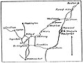
 1908 map of the Newport and Providence Railway.jpg 867 × 1,328; 732 KB
-
 1909 streetcar map of New England.jpg 2,653 × 4,000; 1.66 MB
-
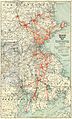
 1910 Rhode Island railroad map.png 2,836 × 3,500; 13.43 MB
-
 1910 Tri-state Trolley Map.jpg 2,864 × 4,740; 3.4 MB
-
 1910s Bay State Street Railway map.png 3,500 × 6,149; 41.66 MB
-
 1911 aerial map of Boston and Northern Street Railway and Old Colony Street Railway.png 3,500 × 6,193; 43.94 MB
-
 1911 Tri-state Trolley Map.png 2,583 × 3,500; 17.01 MB
-
 1912 aerial map of the Bay State Street Railway.png 3,500 × 6,285; 50.46 MB
-
 1916 aerial map of the Bay State Street Railway.png 3,500 × 6,279; 39.4 MB
-
 Birds Eye View of Street Railway Routes in New England, 1904.png 2,392 × 3,500; 20.63 MB
-
 Birds Eye View of Street Railway Routes in New England, 1905.png 3,500 × 5,018; 53.03 MB
-
 By trolley through eastern New England (1904) (14776558855).jpg 2,656 × 3,872; 855 KB
-
 New Haven electric railway subsidiaries.svg 1,400 × 800; 2.29 MB
-
 Norwich and Worcester map.jpg 792 × 550; 138 KB
-
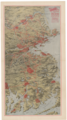
 Shore Line map.JPG 2,013 × 1,983; 624 KB


_(14776558855).jpg)


